

Josephine Peak is one of the best hikes with no crowds near Los Angeles. Tucked away in the Angeles National Forest off Hwy 2, this moderate hike is a must-do for SoCal locals.
HIKE TO: Josephine Peak
TRAILHEAD: Josephine Peak Road at Clear Creek Fire Station
MILES: 8.08 miles out and back
TIME: 2.5 hr
DIFFICULTY: moderate
ELEVATION: 5,538 ft
ELEVATION GAIN: 1,879 ft
HIKE PERMIT: no
LOCATION: Angeles National Forest Southern California
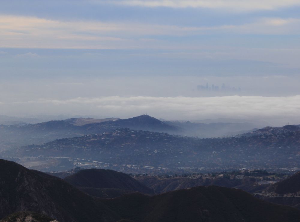
Josephine Peak is one of my favorite local hikes off Angeles Crest (Hwy 2) in LA’s Angeles National Forest. The moderate-level trail stretches across 4 miles one-way and ends with breathtaking mountain layer views and on a clear day, you will even see Downtown Los Angeles. There is also the possibility to extend your hike to the mountaineer’s route on Strawberry Peak or even all the way to Mt Lawlor for a challenging 3-peak traverse day.

Where is Josephine Peak?
Josephine Peak is located about 12 miles north of La Cañada in Angeles National Forest and the San Gabriel National Monument near Los Angeles, CA. The trailhead starts across from the Clear Creek Fire Station by the Clear Creek Information Center which is]temporarily closed. It is where the Angeles Forest Hwy N3 meets the curvy Angeles Crest Highway 2.
3 Parking options: There is a large parking lot at Clear Creek Info Station, a small dirt pull-out parking area at the corner of the intersection, and some parking along the Angeles Forest Hwy N3 road in front of the fire station. The last option is directly across the street from the trailhead.
How high is Josephine Peak?
Josephine Peak’s elevation is 5,538 ft, just shy of its popular neighbor Strawberry Peak.


Josephine Peak Trail
The hike up to Josephine Peak follows a wide fire road, Josephine Peak Road, the entire way with a steady elevation gain of 1,879 ft in 4 miles. This makes it a very mellow trail if you’re looking to get out for a hike with some mileage but nothing strenuous.
You can actually connect this hike with Strawberry Peak and Mt Lawlor for an epic traverse if you arrange a car shuttle! Angeles Crest is a very winding road and dangerous to walk back on – trust me, I’ve tried hitchhiking.
The trail starts off mostly exposed to the sun with views of the mountains and valley below. There is also more elevation gain in the first half of the hike than the latter.
At 2.42 miles (4,887 ft), you reach Josephine Gap which is the junction for Strawberry Peak. You can take that trail to the right and continue on to the class 3 mountaineers route up to Strawberry Peak, or you can continue on the wide fire road towards Josephine Peak. From this junction, there is also a direct ridge route that goes straight to the summit, but I would not recommend this. I’ve tried to take it downwards from the summit and it’s very overgrown and not totally clear or maintained. To put it simply, that ridge is an unpleasant hike.
Continuing on, the wide fire road trail to the summit now has some longer switchbacks and shade, depending on what time of day you hike. This final section of the hike is 1.6 miles with 650 ft of elevation gain and offers different views looking north, until the final stretch which spirals around to the summit of Josephine Peak. Alternatively, you can follow the short path straight up to the summit once you see the towers on the summit.
The summit of Josephine Peak has communication towers but you still get 360-degree panoramic views of the San Gabriel Mountains including Mt Wilson, the valley, and the city below.
Moving at a constant moderate pace, you can get up to the summit in about an hour and a half. There are also some wildflowers along this trail in the Spring but if you’re looking to see a superbloom, you’ll definitely have better luck at one of these other wildflower hikes.
Fun Fact: There’s a lot of mistletoe on this trail after you pass the Josephine Gap!


After enjoying the views and taking a break, head back down the way you came!
What to Pack for a Moderate Day Hike in Angeles National Forest
- Gregory 18 Nano Day Pack
- Lululemon Wunder Under leggings
- Sunscreen
- Altra Lone Peak Trail Shoes
- Eddie Bauer Merino Wool Socks
- Snacks
- Water
- Sun hat
Booking travel soon?
Please consider using my affiliate links below. It costs nothing additional for you but helps me maintain the ever-increasing costs of running a travel blog:
General travel through Tripadvisor here.
Book your flights here.
Book your accommodations here on Expedia, Booking.com, Hotels.com, and VRBO.
Book your car rentals here.
Book your tours here.
Book your travel insurance here.
Shop my favorite gear here.
Tiff, the owner and author of Follow Tiff’s Journey, is a California/ Colorado-based adventurer and outdoor connoisseur who divides her heart between the Eastern Sierra Mountains and the Colorado Rocky Mountains. Despite her fear of heights, she’s become a seasoned mountaineer, ultralight hiking and backcountry camping enthusiast, expert road trip planner, and a fervent explorer of alpine lakes, natural hot springs, and sandstone canyons.
With 10 years of experience exploring the outdoors, her blog is your go-to source for all things wilderness, offering invaluable insights and pro tips, essential gear recommendations, and awe-inspiring stories from her adventures.
Join Tiff on her quest to share the wonders of nature and inspire others to follow their own path in the great outdoors.