
HIKE TO: Strawberry Peak
TRAIL: Mountaineer's Route from Colby Canyon
MILES: 6.46 miles out and back
TIME:  2:47 hrs up, 2:17 hrs down
DATE I WENT: 12/20/20
DIFFICULTY: moderate - difficult
ELEVATION: 6,165 ft
ELEVATION GAIN: 2,684 ft
PARKING PERMIT: yes
LOCATION: Angeles National Forest
Where is Strawberry Peak?
Strawberry Peak is the prominent peak shaped like a Strawberry which you see from downtown LA and OC, located in the Angeles National Forest of the San Gabriel Mountains. It is located roughly 8-9 miles drive off the west end of Angeles Crest Hwy and there are three hike options to reach the summit: Strawberry Peak trail from Red Box Gap, Colby Canyon to Strawberry Peak West Ridge Trail, and Colby Canyon to Strawberry Peak Mountaineers Route (this trip report).
Strawberry Peak Mountaineers Route from Colby Canyon
Strawberry Peak’s Mountaineers Route is considered a class 2-3 climb, meaning it’s a scramble that requires the use of your hands on boulders and route-finding skills with some exposed sections on a steep hillside (which I found were easily avoidable this time around). There are very few popular scrambling routes near Los Angeles and this is one of them. The Strawberry Peak hike is about 2 miles on a normal dirt hiking trail, then 1 mile on the mountaineer’s route.
I first hiked this trail in April 2017 – I hiked up to Strawberry Peak via the Mountaineer’s Route but was too scared to come back down the same way so I lollipop-looped through the Strawberry Peak West Ridge Trail back down, connecting back with the Colby Canyon Trail, passing through San Gabriel Mountains National Monument and Strawberry Meadow. Note: I ended up back at the same trailhead, this is not the standard Strawberry Peak trailhead.
I’ve always wanted to come back and hike the Mountaineers Route to the peak both up and down and when I finally went back for it this month… it wasn’t bad at all! I look back and wonder why I was so scared the first time.

Strawberry Peak Trail Report
Colby Canyon Trail to Strawberry Peak Mountaineers Route
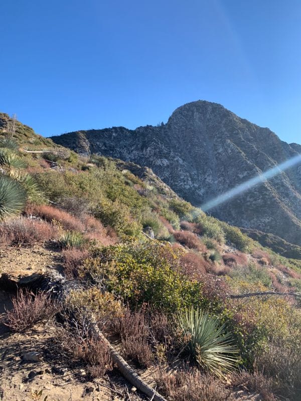
[Sunday, Dec 20, 2020] The trailhead for Strawberry Peak’s mountaineer’s route starts at the Colby Bridge Day Use Area which is just a dirt pullout on the left. You hike the Colby Canyon Trail through Daisy Canyon (passing a dry waterfall) for a little over a mile and then the trail opens up with full sun exposure for the remainder of the hike. There are some switchbacks before reaching Josephine Saddle just 2 miles from the trailhead with 1,381 ft of elevation gain. From here, you’ll head on the mountaineer’s route toward Strawberry Peak.


Strawberry Peak Mountaineer’s Route to Summit
The mountaineer’s route begins straight up the mountain on your right towards Strawberry Peak – it’s a 1,275 ft elevation gain in 1.23 miles with two scramble sections and a flat-ish hiking trail in between that requires a little route finding and bushwhacking, but ultimately you’re just heading in the direction of Strawberry Peak in front of you so all trails will connect.
You approach the beginning of the route from the left side of the mountain (from the saddle, continue on Colby Canyon Trail for just a couple of steps, and make a sharp right onto the worn-ish dirt path. Note: if you hike down the lollipop trail through the meadow like I did my first time, this is where you’ll reconnect with this trail).


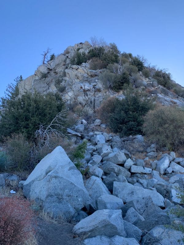
I found the first section to be more nerve-wracking than the second. The second scramble is actually longer and higher with more exposure (& more fun) but I think the first one made me nervous because it was very strong winds and it’s been a while since I had done something like this. After the first scramble, anxiety and my fear of heights settled in. I already started toying with the idea of hiking down a trail instead of climbing down this route. But coming down the mountaineer’s route was the goal of this hike so I distracted myself in conversations with my hiking partner.
Mind Over Matter
Reaching Strawberry Peak and Thoughts Climbing Down the Mountaineers Route
After reaching the summit of Strawberry Peak, I knew I was only halfway through the adventure. Going down always frightens me more than going up. We enjoyed the summit off to the sides (due to crowds) for well over an hour before heading down. The idea of going down the mountaineer’s route gave me a lot of anxiety, but I was also really freaking excited about it. Maybe I came up a harder way the first time, or maybe I’ve just been in more similar and comfortable adventures since the last time I was here, but the scramble was actually really easy and fun! There were maybe two moves where I questioned how it would be going down, but it wasn’t as bad as I built it up in my head.


Random Thoughts from This Experience
- Having long legs helped 😛
- Since I’m scared of heights, I know facing the mountain backward when going down usually helps a lot (& I do that for other hikes). Still, I found it easier to face forward/sideward so I could see where I was going down. Maybe it’s a sign I’m getting more comfortable with heights?
- This is a beginner-friendly route for any hiker that wants to try mountaineering/ scrambling and has a good sense of direction, climbing, and safety. Just do your research before you go 🙂
- Wear shoes with a good grip
- Tug on all the rocks before putting your weight on it
- Bring a sun hat!!
Gear I Used on This Hike
- Eddie Bauer Day Pack
- 2L Hydration Reservoir (Bladder)
- Sun hat *must have*
- Ultralight hiking boots (I believe my current shoes are not available anymore but all of my Adidas Terrex all have great grip on the soles)
- Lululemon leggings
Thanks for Reading!
I’d love to hear your thoughts in the comments below. Please don’t forget to practice leave no trace 🙂
Other Posts You May Like:
- Hike with the Best View of the Hollywood Sign
 Hike the Innsdale Trail for the best views of the Hollywood Sign. This hike is short and east with close views in less than one mile.
 - 10 Malibu Hikes You Need to Do (Ocean View Hikes, Easy Hikes, Best Hikes)
 There are many hikes along the coast in Malibu that offer beautiful ocean views & some gems deeper in the Santa Monica Mountains
 - A Complete Guide To Malibu Creek State Park
 Malibu Creek State Park in the Santa Monica Mountains offers an easy escape to nature to hike, rock climb, fish, or camp! Plan a day trip or weekend adventure with this guide
 - Cowles Mountain Hike – Highest Peak in San Diego City
 Cowles Mountain is the tallest point in SD with 360 views of the city, beach, and mountains. This short but steep hike is a worthy quick workout
 - 13 Best Sunset Hikes in Los Angeles (by a local)
 LA has some of the best views for sunset hikes, ranging from city to ocean to mountain views. See my guide to the best (and my favorites) sunset hike views.
Booking travel soon?
Please consider using my affiliate links below. It costs nothing additional for you but helps me maintain the ever-increasing costs of running a travel blog:
General travel through Tripadvisor here.
Book your flights here.
Book your accommodations here on Expedia, Booking.com, Hotels.com, and VRBO.
Book your car rentals here.
Book your tours here.
Book your travel insurance here.
Shop my favorite gear here.
Tiff, the owner and author of Follow Tiff’s Journey, is a California/ Colorado-based adventurer and outdoor connoisseur who divides her heart between the Eastern Sierra Mountains and the Colorado Rocky Mountains. Despite her fear of heights, she’s become a seasoned mountaineer, ultralight hiking and backcountry camping enthusiast, expert road trip planner, and a fervent explorer of alpine lakes, natural hot springs, and sandstone canyons.
With 10 years of experience exploring the outdoors, her blog is your go-to source for all things wilderness, offering invaluable insights and pro tips, essential gear recommendations, and awe-inspiring stories from her adventures.
Join Tiff on her quest to share the wonders of nature and inspire others to follow their own path in the great outdoors.
Another wonderful write-up, this time on your Strawberry Peak adventure. That’s a tough and potentially dangerous route. Going up through Colby Canyon is a breeze, however after that, like you stated, it’s a real scramble and very easy to loose your footing. It would be tough for rescue personnel to reach you without putting themselves and the copter in danger. We prefer the route from Red Box—longer, but safer.
Pingback: Hike Mount Lawlor 5928 ft. in Angeles National Forest