
CLIMB TO: Mount Whitney
TRAILHEAD: Whitney Portal
ROUTE: Mountaineers Route
MILES: 10.9 miles
TIME: 14:50 hrs
DATE I WENT: 4/24/21
DIFFICULTY:  moderate-strenuous
ELEVATION: 14,505 ft / 4,421 m
ELEVATION GAIN:  6,063 ft
PERMIT: yes
PARKING PERMIT: no
LOCATION: Inyo National Forest, Eastern Sierra CA

I’ve day hiked it… I’ve backpacked it… and now I’ve climbed Mount Whitney via the mountaineer’s route. So which way is best? Well, that would depend on what type of adventure you are looking for.
Do you need a permit for the Mountaineers Route on Whitney?
Yes, quote season is May 1 – Nov 1 but even when you hike or climb Mt Whitney in the off-season, you still need a permit! Read more about Whitney permits here.
How Hard is the Mountaineers Route Mt. Whitney?
Mount Whitney (14,505 ft) is the tallest peak in the contiguous US and climbing the Mountaineer’s Route is not one to be taken lightly. Not only is the couloir steep, it’s at high altitude which can be a separate issue if your body is not used to it. The approach to the base of the climb is also not a walk in the park — be prepared for a strenuous day out.
Can Beginners Climb Mt Whitney?
Anyone with the proper skills, training, technique, and gear can climb Mt Whitney; however, please be sure you have experience or hire a guiding service for this. Mount Whitney was my 4th mountaineering objective, after Matterhorn Peak, Mount Baldy, and Mount Shasta, and definitely one I would recommend.
Know Before You Go:
- A permit is required year-round but quota season starts May 1. For overnight trips, you will need a permit for North Fork of Lone Pine Creek.
- The Mountaineers Route is commonly done (& best done) when snow is present to avoid rockfall so I’d recommend going in April if you’re ready… BUT BE PREPARED & READY.
- Do not attempt the chute without an ice ax and crampons if snow is present – & know how to use your gear before you go.
- If you are going in the middle of winter, be aware of snow levels because post-holing is very unpleasant
- Be prepared to hike the road to Whitney Portal in the Winter/ early Spring – the road will likely be closed at one of the two gates. For our first attempt in Mar 2021, we hiked from the very bottom of the first closed gate which added an additional 3.6 miles with 1,680 ft of elevation gain. For our second attempt in April 2021, we started from the second closed gate which only added 0.32 miles.
- Please note that Springtime often has better winter mountaineering conditions as the snow has had time to firm up after going through the freeze-thaw cycle, which allows for more efficient snow travel and less post-holing.
- Be aware of current conditions, avalanche risks, etc.

Trail Report: Climbing Mount Whitney via Mountaineers Route in Spring
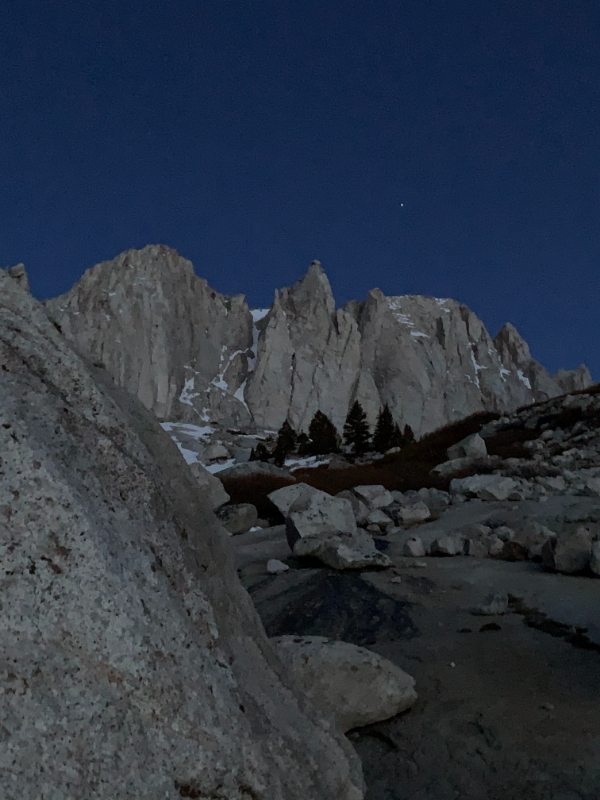
We started from Whitney Portal at 2:18 am with our day packs (gear list below). At 2:39 am, 0.8 miles from the TH, we reached the junction to turn right onto the Whitney’s Mountaineers Route, aka North Forth of Lone Pine Creek. Continuing straight would follow the main Whitney Trail.


The route to get to Lower Boy Scout Lake in the Spring heads right up the Ebersbacher ledges, and then to the left of Lower Boy Scout Lake. During the winter, however, the whole area is covered in snow so you simply go straight up (small switchbacks) directly to Lower Boy Scout Lake. On a normal snow season, it’s likely under snow in March. For our first (failed) attempt mid-march last year, it was all snowy. For our second (successful) attempt at the end of April, there wasn’t enough snow and we went the standard route through the E ledges.
We reached Lower Boy Scout Lake 2.54 miles from the TH by 4:39 am and hiked up the snowy trail to the left. This part had a lot of boulders to go around and at 5:30 am, daylight hit. The sun rose at 6 am just as we were passing Clyde Meadow and approaching next to Upper Boy Scout Lake.


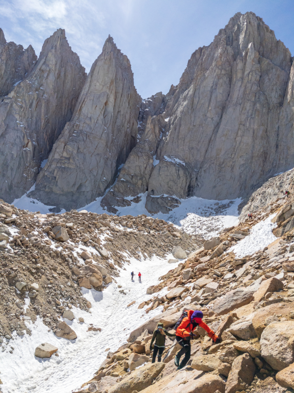
We reached the camp by Iceberg Lake (12,633 ft) at 7:24 am, 4.6 miles from Whitney Portal. We took a long break here to fuel up for the climb ahead. It was pretty windy and this is where the fun part begins.
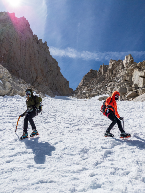
We got moving again around 8:15 am and started following the conga line up the chute for Whitney’s Mountaineers Route. There were SO MANY people and things falling down like snow chunks and water bottles! After all the mountaineering I’ve done now, I’ve never seen a crowd like this on the mountains… but it was also the last weekend before permits were implemented so I assume that’s likely why.


The chute starts off more mellow but as we moved up, we ended up roping up. This was the climb that I learned I move a LOT faster when I’m attached to a rope. It’s a mental thing for me – I’m terrified of heights and the idea of sliding off a mountain so being attached to a rope helps keep the fear in check so I can just focus on the physical aspects of the climb. The chute from Iceberg Lake to the Notch is 1 mile with 1,490 ft of elevation gain and an average slope of 39°, the max slope of 68°.


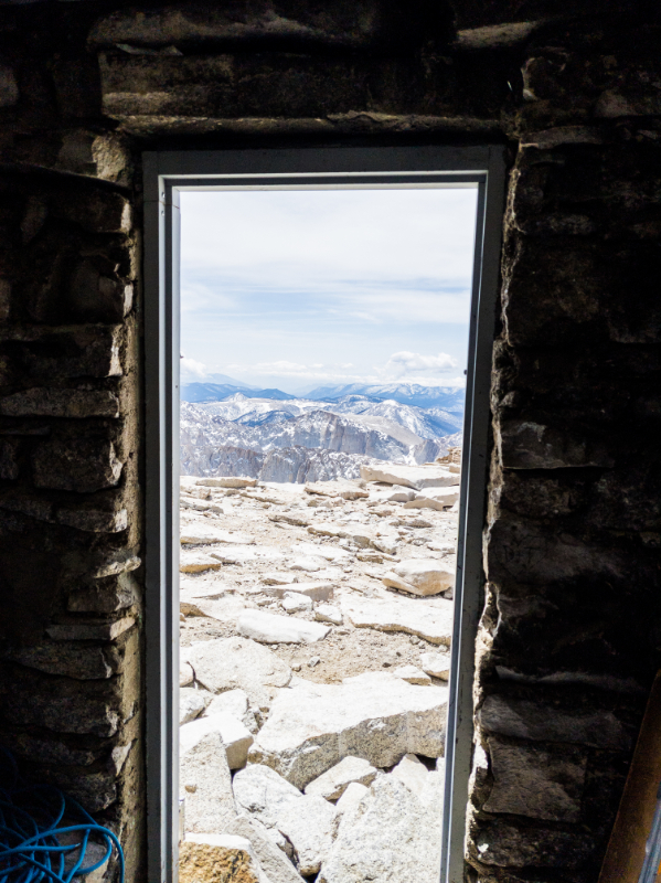
We moved slowly and carefully and reached The Notch (14,128 ft) at 10:40 am, 5.25 miles from Whitney Portal. We had another snack break here, wrapped around the mountain to head up the final 300 ft of class 3 scramble at the end which was not as scary as I thought it would be. In fact, it was actually quite fun – just annoying how many people there were and having to wait.
We made it to the summit of Mount Whitney (my fourth time) via the Mountaineers Route (my first time) at 11:32 am. 5.33 miles and 6,063 ft of elevation gain from Whitney Portal.


The snow was firm when we went through the entire trail on the way up, but as the day went on, the sun melted the snow and made it softer.


We got back to Whitney Portal just before 6 pm, headed back to Alabama Hills to climb, and got on the Shark Fin the next morning before driving back home.

Thanks for Reading
I’d love to hear your questions, comments, suggestions below! 🙂
& please don’t forget to practice LEAVE NO TRACE
Other Posts You May Like:
- Dragon’s Tail Couloir – Colorado Snow Climb in Rocky Mountain National Park
- Crampons vs Microspikes: Differences and When to Use
- AIARE 1: Should I Take an Avalanche Course?
- Climb San Gorgonio from South Fork Trail and North Face
- Climb the Mountaineers Route on Mount Whitney 14,505 ft
Hotels in Lone Pine, CA
Booking travel soon?
Please consider using my affiliate links below. It costs nothing additional for you but helps me maintain the ever-increasing costs of running a travel blog:
General travel through Tripadvisor here.
Book your flights here.
Book your accommodations here on Expedia, Booking.com, Hotels.com, and VRBO.
Book your car rentals here.
Book your tours here.
Book your travel insurance here.
Shop my favorite gear here.
Tiff, the owner and author of Follow Tiff’s Journey, is a California/ Colorado-based adventurer and outdoor connoisseur who divides her heart between the Eastern Sierra Mountains and the Colorado Rocky Mountains. Despite her fear of heights, she’s become a seasoned mountaineer, ultralight hiking and backcountry camping enthusiast, expert road trip planner, and a fervent explorer of alpine lakes, natural hot springs, and sandstone canyons.
With 10 years of experience exploring the outdoors, her blog is your go-to source for all things wilderness, offering invaluable insights and pro tips, essential gear recommendations, and awe-inspiring stories from her adventures.
Join Tiff on her quest to share the wonders of nature and inspire others to follow their own path in the great outdoors.
M
Amazing accomplishment, Tiff! Great write-up, too. Really helpful information!
How do you meet like-minded people to go on all these adventures with?
Hi Martha! I’ve met a bunch through social media and I actually JUST set up a private FB group so my community can connect and meet up for hikes if you want to check it out (literally just launched it an hour ago so maybe give it some time):
https://www.facebook.com/groups/followtiffsjourneyhikingfriends