

Sedona, Arizona needs to be on every hiker’s bucket list. It is renowned for its stunning red rock formations and is known to be an area of vortexes and healing properties. Sedona is located about 2 hours north of Phoenix and 45 minutes south of Flagstaff in Coconino National Forest which includes Red Rock Secret Mountain Wilderness and Munds Mountain Wilderness.
There are so many hiking trails all around Sedona and the nice thing about the hikes out here is they are all mostly short. There are a lot of really cool geological formations and features, to say the least, including numerous caves — Sedona is a stunning place to hike and relax in beautiful scenery.
Here is everything you need to know for the best hikes in Sedona including trailhead, parking, mileage, average duration, notable sights, and planning recommendations.
Parking: Red Rock Pass
The Red Rock Secret Mountain Wilderness and Munds Mountain Wilderness are both located in Coconino National Forest which requires a Red Rock Pass. It costs $5/ day or $15 for one week, and $20 for a year and you can purchase this online or at a self-ticket kiosk at the trailheads.
Pro Tip:
If you have the America the Beautiful Pass (aka US National Park Pass), you can use this instead of the Red Rock Pass + you can use it for many other public land recreation during the year, including National Parks and National Forest lands!
Click here to buy America the Beautiful Pass.
Booking travel soon?
Please consider using my affiliate links below. It costs nothing additional for you but helps me maintain the ever-increasing costs of running a travel blog:
General travel through Tripadvisor here.
Book your flights here.
Book your accommodations here on Expedia, Booking.com, Hotels.com, and VRBO.
Book your car rentals here.
Book your tours here.
Book your travel insurance here.
Shop my favorite gear here.

Best Sedona Hikes
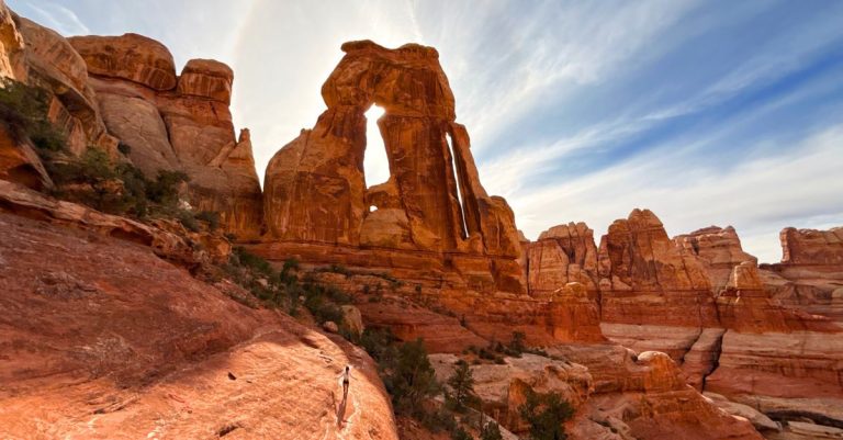
Devils Bridge Sedona
Devils Bridge is an iconic natural sandstone arch, offering breathtaking views of the red rock landscape.
- Trailhead: Accessible from Dry Creek Road. Park at Dry Creek Vista Trailhead
- Distance: Approximately 3.6 miles round trip.
- Duration: Plan for around 2-3 hours.
- Additional Information: The trail is moderately strenuous but offers a rewarding experience. If you have a high clearance 4wd vehicle, you can drive all the way up to the Devil’s Bridge Trailhead which makes the hike only 0.6 mile one way.

From the trailhead, you will hike on Forest Road 152 for 1.2 miles until you reach the official Devils Bridge Trailhead. This part of the hike is on red sand/ dirt and is relatively flat. There may be cars that drive past and kick up the dirt so be mindful of vehicles on the road.
From the Devil’s Bridge Trailhead, the hike is only 0.6 miles one way with 400 ft of elevation gain. This trail has some shade and is more narrow on a dirt path.
There are several trail options to reach Devils Bridge in Sedona but this is the shortest and most common.
You can also rent an off-road Polaris in Sedona for a couple of hours to access the trailhead for your hike.
Cathedral Rock Trail
Cathedral Rock hike provides stunning panoramic views and is a favorite among hikers — it’s personally one of my favorite hikes in Sedona and a must-visit on every trip out here.
- Trailhead: Cathedral Rock Trailhead is located off Back O’ Beyond Road.
- Distance: About 1.4 miles round trip.
- Duration: Expect 1-1.5 hours.
- Additional Information: A recreation pass is required for parking in the lot here. This trail is considered moderately difficult, with steep sections.

The hike to the “end of trail” sign is a short trail with open views for most of the hike. There are very large and obvious cairns that mark the trail and the path isn’t clear-cut; it has a bit of class 1 scramble feel to it as the terrain is uneven throughout the whole hike.
Pro Tip: Once you reach “the end” head to the left side on the narrow ridge, climb up a steep chute, and you will pop out to incredible views not seen from the end everyone stops at.


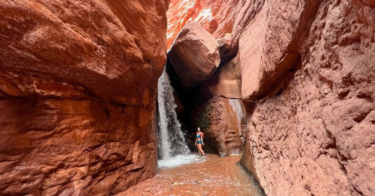
Soldiers Pass Sedona and Seven Sacred Pools
The unique Soldiers Pass Trail has a couple of highlights including the Seven Sacred Pools and a cave.
- Trailhead: Soldiers Pass Trailhead is accessible from Soldiers Pass Road.
- Distance: Approximately 4 miles round trip.
- Duration: Plan for around 2-3 hours.
- Additional Information: This hike is close to the Devil’s Bridge Hike so I would plan them for the same day

Soldiers Pass trail is about 2 miles one way but there’s a cool cave-like feature that’s a short detour from the main trail.
The hike starts with a short, easy 0.3 walk to the Devil’s Kitchen which is a large sinkhole, and then continues to the Seven Sacred Pools. Make sure you pay attention and keep an eye out for it so you don’t miss it like I did the first time. When there isn’t much water in the pools, it can be easy to miss.


At 2 miles from the trailhead, you will reach Soldier Pass. But before you arrive there, there is a detour to an unmarked spur trail on your right about 1.3 miles from the trailhead that leads to the Soldiers Pass Cave.
Hike in the direction of the wall and you will see the small cave as you get closer to it. Like with most caves in Sedona, the trail that crawls up into the cave can be steep, contains loose rocks and boulders, and requires some scrambling. Please be mindful of other hikers that may be around.


Boynton Canyon
Boynton Canyon offers a serene hike surrounded by towering red rock formations and a cool subway-like tunnel feature at the end which makes for nice photo opportunities.
- Trailhead: Start from Boynton Canyon Trailhead off Boynton Canyon Road.
- Distance: About 6 miles round trip.
- Duration: Expect 3-4 hours.
- Additional Information: This is a moderately challenging trail with captivating scenery.

Boynton Canyon is a fairly flat and easy hike for most of the trail. The hike goes through the pines in the valley so it’s not the most scenic hike as a lot of the views are hard to see, but the final view is worth it.
At 2.48 miles, you will see the popular “tunnel” feature you crawl up into is. The popular photos is shooting from inside looking out, so so you will have hike up the narrow and steep climb to reach the top.
In addition to the popular tunnel, you can continue to hike along the edge to see old ruins and where the people used to live. The views from here open up to the whole valley in the canyon below.


Birthing Cave
Discover the intriguing Birthing Cave, a unique geological formation.
- Trailhead: Long Canyon Trailhead
- Distance: 1.9 miles miles out and back.
- Elevation Gain: 316 ft
- Duration: Plan for around 1 hour.
- Additional Information: The trail offers cultural significance and stunning vistas.

The birthing cave is growing in popularity. While it is not one of the touristy hikes, it’s a popular one for content creators and with good reason.
The hike starts on Long Canyon Trail but there is a trail junction 0.6 miles in which you will keep left to break off the Long Canyon Trail and head towards Birthing Cave.
Hiking to the cave took us about 24 minutes and 18 minutes into our hike, we could see the cave from a distance — it kind of looks like a heart.


The hike is very easy from the trailhead to the bottom of the Birthing Cave. The trail is on a flat, narrow dirt path lined with shrubs and trees.
It is a short but steep climb from the base of the cave to get in, and the cave can definitely be slippery. The cave is very shallow and very sloped. Make sure you have hiking shoes with good, grippy soles if you plan to climb higher into it.
I’m scared of heights and falling and have done a lot of sketchy things, but walking along the inside of this one higher up kind of freaked me out.
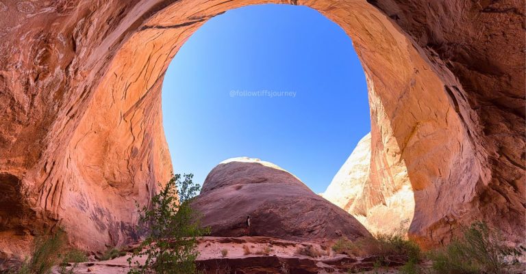
Keyhole Cave
Keyhole Cave provides an adventurous and lesser-known hiking experience in the Red Rock Secret Mountain Wilderness. This may be the most “secretive” and hard-to-access spot on this Sedona must-hike list.
- Trailhead: Sugarloaf Trailhead
- Distance: About 2 miles round trip.
- Duration: Expect 1-1.5 hours.
- Additional Information: The cave adds an exciting element to the hike.

Everything You Need to Know to Find Keyhole Cave
It’s only a 15 minute walk to reach the base of the cave if you don’t get loss but the hike requires off-trail hiking and the climb up into the cave, like most others, is steep — but this is more vertical than others.
The trail starts on Teacup Trail from Sugarloaf Trailhead for about half a mile and then you reach a trail junction for Thunder Mountain on the left and Teacup Trail on the right. Head left, but only for a couple of steps, and then look right for a faintly used trail and start your off-trail hike through the wash.
Off-trail simply means there is no established and maintained trails for the hike and you need to have a good sense of direction and route-finding skills.
While you can just hike generally in the direction of Keyhole Cave from this right turn turn-off by the Teacup Trail/ Thunder Mountain junction, I find it easier to follow a dry wash but choose your own adventure!
The off-trail hiking portion is about 0.75 miles. As you approach the cave and get close, break off from your path and head directly towards the cave.
Here are the GPS coordinates for the cave to plug into your GPS.


Getting into Keyhole Cave
Climbing into this cave is probably the most dangerous of all the popular Sedona caves listed here.
The cave wall is very vertical and I’m told there is often a rope there to assist in getting you up into it. The rope, unfortunately, was not there when we went, and climbing in was a bit of a mental challenge for me (I’m really afraid of falling). It’s not the going up that freaks me out as much as knowing I can come down safely.
We climbed up the left side of the cave (facing it) where the rope used to be and when you look at the wall, you can find little pockets to tuck your feet and put your hands. But this is definitely not something I would recommend for someone with no scrambling experience or who lacks the adventurous soul with a little bit of spice. Be confident in your moves.
The view from inside looking out makes for a stunning photo, but the views are not necessarily any better than what you see from the base of the cave.


Bell Rock in Sedona
Bell Rock is an iconic formation with a trail leading to its summit. There are multiple variations to hike around here and this description is for the hike and climb up Bell Rock Butte.
- Trailhead: Bell Rock Trailhead is accessible from Bell Rock Pathway.
- Distance: Approximately 1 mile round trip.
- Duration: Plan for around 1 hour.
- Additional Information: A relatively easy and popular hike with outstanding views.

Bell Rock is one of the first hikes you come across just as you are driving into Sedona from the South, which made it the perfect chill hike for the morning we left Sedona to drive back to Los Angeles, CA.
This loop is an easy-moderate hike that’s great for the whole family. You can hike along the bottom and get a nice view of Bell Rock Butte up close for an easy hike, or climb up the rock formation for a fun moderate adventure.
There are three parking lots to directly access Bell Rock Trail but the Bell Rock Trailhead by the Courthouse Vista is the most direct for this hike.


The hike starts on flat ground as you walk towards Bell Rock Butte and once you reach the base of the geological formation, it’s a bit of a choose your own adventure trail. There are many paths you can follow to climb up Bel Rock Butte and it wraps around.
While there are flat sections to walk on, there can be sloped terrain as well and I’d recommend making your the soles of your hiking shoes have good traction.


There is an alternative 3.6-mile easy vista hike near Bell Rock called the Bell Rock Pathway. This trail follows the flat ground where you get grand views of Bell Rock and Courthouse Butte without having to hike up anything. This hike is a good option for those looking for more of a “walk in the park” outting.

West Fork Oak Creek Trail
West Fork Oak Creek is a scenic trail along a beautiful creek.
- Trailhead: Start at Call of the Canyon trailhead.
- Distance: About 7 miles round trip.
- Duration: Expect 4-5 hours.
- Additional Information: The trail offers a peaceful and lush canyon experience near water.

This hike is just north of Sedona and different than any other hikes on this list. This hike follows a creek between deep canyon walls and ends at a tunnel similar to the Subway Hike in Zion National Park.
The West Fork Oak Creek trail is two miles one way but there is a hike to reach that trailhead from Call of the Canyon, making the full trail roughly 3.5 miles one way.
There is fall foliage along this trail in the Fall time and a Summer visit may help escape the heat. The creek does not contain enough water that you can dip into, but does offer several creek crossings.


Airport Loop Trail
Airport Loop Trail provides panoramic views of West Sedona, Capitol Butte, Wilson Mountain, and the surrounding red rocks. If you are short on time but want to get in a quick hike with views, this one is for you!
- Trailhead: Airport Mesa Parking accessible from Airport Road.
- Distance: Approximately 3.3 miles round trip.
- Duration: Plan for around 2 hours.
- Additional Information: A moderate trail with stunning vistas.


Parking here gets very crowded as it’s a quick little easy-to-access hike from town with incredible views.
The trail starts with a lot of steps and basically goes up the whole time. You can simply hike to the Sedona Trail View Point at the top in ten minutes for a quick little hike if you just want to get out to catch the sunset views like we did, or make it a full loop.
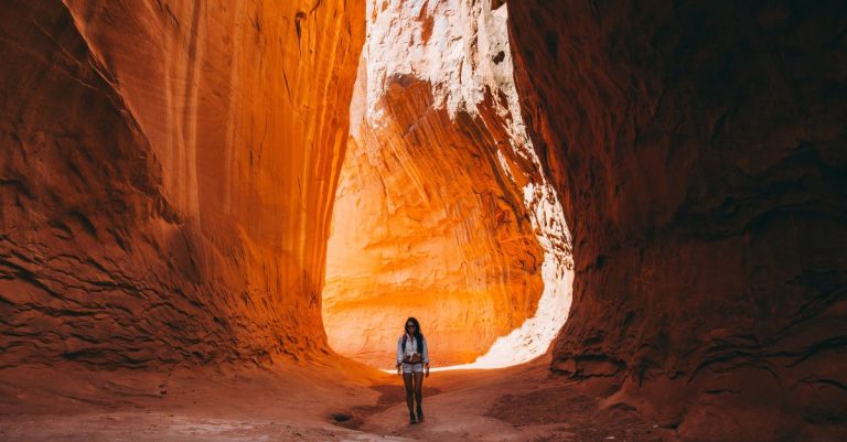
Red Rock Crossing
Red Rock Crossing offers a picturesque setting with views of Cathedral Rock.
- Trailhead: Baldwin Trailhead accessible from Verde Valley School Road
- Distance: About 0.5 miles round trip.
- Duration: Expect a short and leisurely walk.
- Additional Information: Ideal for a relaxed stroll with beautiful scenery.

After recent rain, there are puddles of water which provide beautiful reflections of Cathedral Rock and but Oak Creek also runs back here which makes this a popular and scenic spot for photographers.
The hike here is easy and offers a couple of access points: Red Rock Crossing Trail from Crescent Moon Day Use and Picnic Site, or the Baldwin Trailhead. The first one has a parking fee and the second does not.
We hiked from the Baldwin Trailhead and walked north to the end of Verde Valley School Rd to connect to the Red Rock Crossing Trail, or from the same trailhead you can jump on the Baldwin Trail that also connects to the Red Rock Crossing Trail, you will just have to turn left at the junction to get closer to the creek if you are looking for that iconic shot.


Regardless of which way you choose to go, it’s a short hike to reach Oak Creek and get the reflection shot of Cathedral Rock.


FAQ: Hikes in Sedona
What is the most famous hike in Sedona?
The most famous hike in Sedona is a toss-up between the iconic Cathedral Rock and the Devil’s Bridge.
The Cathedral Rock hike offers stunning panoramic views and red rock formations, and the Devil’s Bridge features a massive natural arch you can walk on with expansive views below making both hikes a must-visit for any hiker.
What is the most scenic place in Sedona?
This is hard to pick because there really isn’t any bad views in Sedona. The red rocks in every direction is simply breathtaking, but one of the most picturesque places for photographers is Red Rock Crossing. This area provides a breathtaking view of Cathedral Rock and offers a serene setting along Oak Creek.
However; as a hiker, I enjoy views from the top with expansive views and Airport Loop Trail and Bell Rock both offer this.
What is the best short trail in Sedona?
For a shorter trail with rewarding views, Devils Bridge Sedona is an excellent choice. Despite its relatively short distance, it offers a unique natural arch and spectacular vistas.
How hard is Cathedral Rock Trail?
Cathedral Rock Trail is considered moderately difficult. It includes steep sections, making it a challenging yet rewarding hike. Ensure you wear appropriate footwear and take your time to enjoy the scenery.
Hikes in Sedona for great views and limited time?
If you’re short on time but still want great views, Airport Loop Trail is perfect. Its moderate difficulty level and panoramic views make it an ideal choice for a shorter hiking experience. I highly recommend coming here for a sunset hike.
Things to Do in Sedona
Where to Stay in Sedona AZ
Booking travel soon?
Please consider using my affiliate links below. It costs nothing additional for you but helps me maintain the ever-increasing costs of running a travel blog:
General travel through Tripadvisor here.
Book your flights here.
Book your accommodations here on Expedia, Booking.com, Hotels.com, and VRBO.
Book your car rentals here.
Book your tours here.
Book your travel insurance here.
Shop my favorite gear here.
More Utah and Arizona Desert Adventures You Might Like


Tiff, the owner and author of Follow Tiff’s Journey, is a California/ Colorado-based adventurer and outdoor connoisseur who divides her heart between the Eastern Sierra Mountains and the Colorado Rocky Mountains. Despite her fear of heights, she’s become a seasoned mountaineer, ultralight hiking and backcountry camping enthusiast, expert road trip planner, and a fervent explorer of alpine lakes, natural hot springs, and sandstone canyons.
With 10 years of experience exploring the outdoors, her blog is your go-to source for all things wilderness, offering invaluable insights and pro tips, essential gear recommendations, and awe-inspiring stories from her adventures.
Join Tiff on her quest to share the wonders of nature and inspire others to follow their own path in the great outdoors.
Do you have a favorite lake or trail in the eastern Sierra’s? I’ve backpacked Kearsarge Pass, Big Pine (North Fork), Honeymoon Lake (Bishop) and Little Lakes Valley so far and I’m looking for a new adventure. Is there a spot that took your breath away?
Hi Darin! A lot of my favorite hikes in the Eastern Sierra Mountains are on my blog! Have you checked out my full Sierra section? The Minaret area is absolutely stunning and also check out Big Pine South Fork if you haven’t.