
HIKE TO: Little Lakes Valley to Gem Lakes and Treasure Lakes
TRAIL: Little Lakes Valley Trail
TRAILHEAD: Mosquito Flat near Mammoth Lakes, CA
DISTANCE: 8.1 miles out and back to Gem Lakes
TIME: 3-4 hours to Gem Lakes
DATE I FIRST WENT: 9/3/18
DIFFICULTY: easy-moderate
ELEVATION GAIN: 673 ft to Gem Lakes
HIKE PERMIT: not for day hikes, yes for backpacking and overnight camping
PARKING PERMIT: no
LOCATION: Eastern Sierra Mountains in California, Inyo National Forest

Little Lakes Valley in the John Muir Wilderness near Mammoth Lakes, CA is aptly named because there are so many lakes to be seen on this hike. The Eastern Sierra Mountains attract hikers of all levels and this relatively flat 4-mile hike to Gem Lakes is a great hike for beginners.
The Little Lakes Valley Trail through Rock Creek Canyon has only 673 of elevation gain, which makes this a popular hike for many.
Hike to 5 alpine lakes before reaching the emerald Gem Lakes with an adventurous option to extend off the beaten path to explore Treasure Lakes.

Booking travel soon?
Please consider using my affiliate links below. It costs nothing additional for you but helps me maintain the ever-increasing costs of running a travel blog:
General travel through Tripadvisor here.
Book your flights here.
Book your accommodations here on Expedia, Booking.com, Hotels.com, and VRBO.
Book your car rentals here.
Book your tours here.
Book your travel insurance here.
Shop my favorite gear here.
What You Will See from Little Lakes Valley Rock Creek Canyon
Rock Creek Canyon is a very scenic hike, one of the best bang-for-your-buck trails in the Eastern Sierra. The highlights of this trail include Long Lake, Chickenfoot Lake which is a short detour from the main Little Lakes Valley Trail, Gem Lakes, and Treasure Lakes. The views of 13,000 ft peaks such as Bear Creek Spire, Mount Dade, and Mt Abbot, make this hike a sight for sore eyes.
Where to Stay Before Hiking Little Lakes Valley to Gem Lakes
- Budget-Friendly: The Hostel California in Bishop — For those searching for a budget-friendly option, Bishop is cheaper than Mammoth and about the same distance away, and hostels are cheaper and fun experiences to meet like-minded new friends!
- Mid-Range: Vagabond Inn in Bishop — This is your standard hotel
- Luxury: Creekside Inn in Bishop — For those searching for a more luxurious stay without paying the premium price of Mammoth accommodations, Creekside Inn is an amazing gem in Bishop! The location also provides easy access to explore up by Lake Sabrina since Mammoth Lakes Basin often gets overcrowded.
- Camping: If you’re into the dirtbag roughing it lifestyle, there is a backpacker’s campground at the trailhead or check out my ultimate guide for camping near Mammoth Lakes.

Where is Rock Creek Canyon?
Rock Creek Canyon is about a 10-mile drive into the mountains from Tom’s Place off the 395 Highway. It is located between Bishop and Mammoth Lakes, California. Rock Creek Canyon is the canyon Little Lakes Valley is tucked away in and the trailhead to start your hike is Mosquito Flat trailhead. This road is closed in the winter usually around the Palisade Campground.
Pro Tip:
While summer at the lakes is a nice time to hike, drive up to Rock Creek Canyon in the Fall for some beautiful golden fall colors. You can see a lot of foliage on the drive up to Rock Creek Lake and the parking lot without having to hike. Visit my Fall Colors in the Eastern Sierra Hiking Guide here.
What is the elevation of Little Lakes Valley?
Little Lakes Valley sits at an elevation just above 10,000 ft.
Fun fact: the Mosquito Flat trailhead for the Little Lakes Valley hike is the highest paved trailhead in the Eastern Sierra Mountains with an elevation of 10,244 ft.
How long is Little Lakes Valley trail?
The hike through Little Lakes Valley is about 4 miles one way with a little bit of elevation gain. Hiking at a leisurely pace, this can take about 1:20 – 2 hours, one way.

What to Pack for Little Lakes Valley
- A small backpack like the Pingora Remote 20 L pack or Gregory Nano 18 L day pack works great!
- Katadyn BeFree Water filter
- Danner hiking boots or Altra Lone Peak if you prefer trail running shoes — go with the boots if you want more support
- Darn Tough Light Hiker Micro Crew hiking socks if you are going in the summer
- Matador Nanodry Towel if you plan to go for a swim — this is the best travel towel you will ever buy!
- A sun hat with a wide brim like the Sunday Afternoons Charter Hat to protect your face
- Sun shirt — the Himali Eclipse Sun Hoodie is a great option to protect your body and face from the sun and heat. Get 10% off Himali with code followtiffsjourney
Little Lakes Valley Trail Description
The Little Lakes Valley hike starts from Mosquito Flat trailhead at 10,244 ft. The parking lot has restrooms and fits a lot of cars but because this is a popular trailhead, it fills up early and fast. However, there are many little pullouts along the side of the road that will only require an extra 10 minutes max usually.
The views from the beginning of the hike are phenomenal with breathtaking views of a cirque of 13,000 ft peaks above the valley. You quickly get views of Bear Creek Spire, Mount Dade, Mount Abbot, Mount Millis, and Ruby Peak.


About half a mile in, you will reach a junction for the Ruby Lake Trail. Stay straight and continue on the Little Lakes Valley Trail. Mack Lake is the first alpine lake you will see without having to go very far at all.
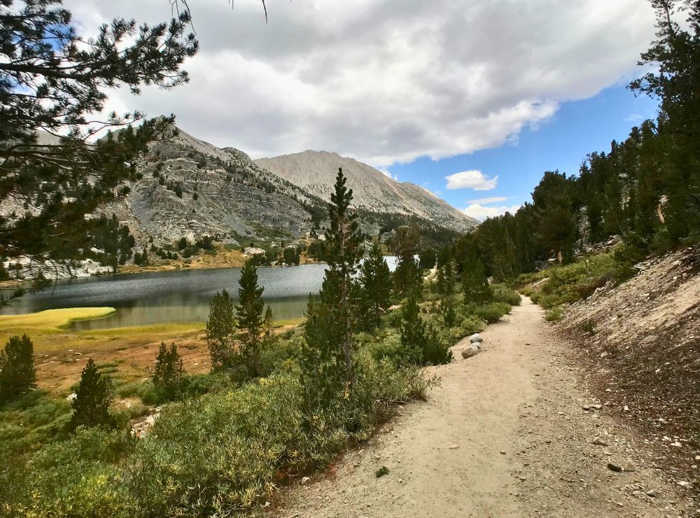
The hike continues relatively flat-ish as you pass Marsh Lake, Heart Lake, Box Lake, and Long Lake which is a very long lake. It’s cool because you get to hike up right along the edge of the lake!
Then you will pass a short detour junction to Chickenfoot Lake which is a 0.7-mile detour (0.4 miles there, and 0.3 miles to reconnect to Littles Lakes Valley Trail). Feel free to skip this lake and head straight to Gem Lakes!
At 3.71 miles from the trailhead and an elevation of 10,917 ft, you will reach the junction for Morgan Pass, Gem Lakes, and Treasure Lakes. The hike to here is only 673 ft of elevation gain so as you can see, this is a family-friendly, easy level high altitude hike.


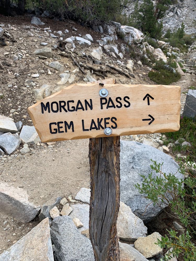

Morgan Pass

If you continue straight, there is a very short hike up to reach Morgan Pass. From the top of the pass, you can see Upper Morgan Lake. I’ve hiked down the other side a little bit, not too far, and the views didn’t get much better but it’s nice from the top of the pass.
You can continue hiking down to Lower Morgan Lake but if you don’t have time to see it all, I’d recommend hiking to Gem Lakes and Treasure Lakes instead of Morgan Pass and Morgan Lakes.


Gem Lakes
If you go right at the junction, you will continue to Gem Lakes and Treasure Lakes which I could recommend. Gem Lake sits at an elevation of 10,944 ft and is easy to reach — it’s a short 0.34-mile hike to get here from the junction, and 4.05 miles from the trailhead.
You will hike on a flat trail through some meadows, along a small lake, cross a wide creek that has some good, large flat stones to step on, and then you will be a Gem Lakes. That creek is a great spot to filter water!
Pro Tip:
Bring your water filter on this hike! There are so many lakes that are easy to access so you can have an unlimited supply to hydrate from (especially on a hot summer day) without having to carry a lot of water weight. My favorite easy-to-use, lightweight water filter for a hike like this is the Katadyn BeFree 1L Water Filter — click here to get yours now.
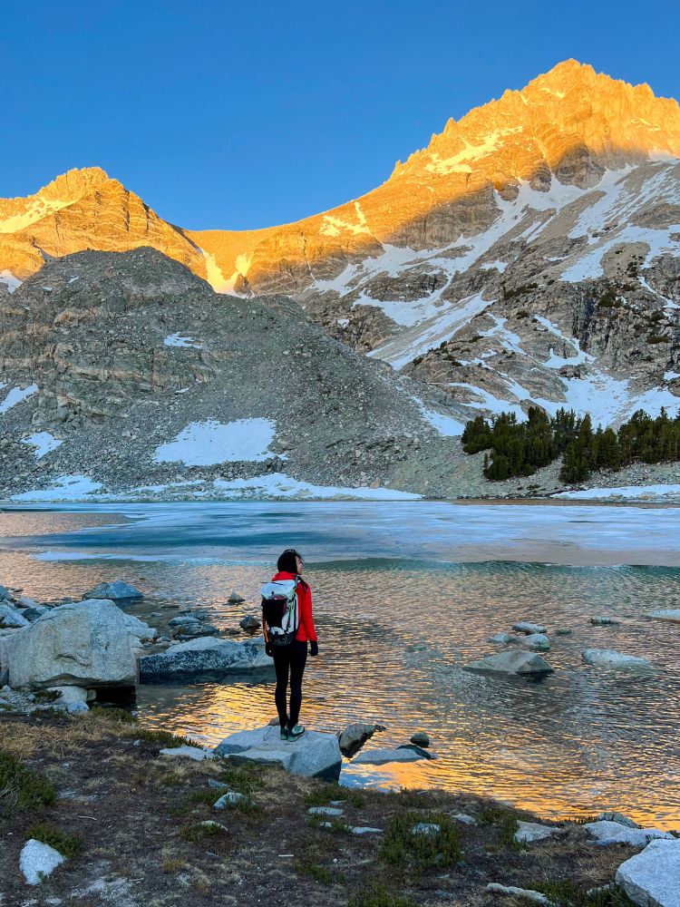
Gem Lakes is pretty big and wraps around the trail so after you take in the emerald-green sights of the lake, make sure you continue hiking to see the rest of the lake further down the trail.
From Gem Lakes you can see Bear Creek Spire and Mount Dade peeking out in the back.


This is a great spot to relax and have lunch! If you’re just looking for an easy hike with beautiful views, this is likely the end of your journey and you can head back the same way.
Treasure Lakes
If you are looking for a little more adventure and familiar with some off-trail hiking, I’d recommend continuing your hike to Treasure Lakes.
If you are trying to climb Bear Creek Spire or Mount Dade, this is where you will start.


Treasure Lakes is about half a mile further from the edge of Gem Lakes, depending on which route you take, but there is no established hiking trail beyond Gem Lakes. There are some used trails that you can tell other hikers and climbers have been on, but you will need a good sense of direction and route-finding skills to hike off the beaten path.
For these cross-country hiking adventures, it is good to have a GPS and satellite device in case you get lost or anything goes wrong. I’d also recommend downloading a gpx file on to your phone before heading out to help guide you.

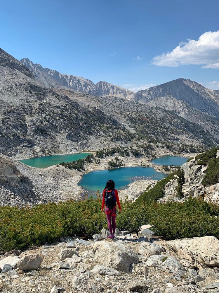

At 4.5 miles from the trailhead and an elevation of 11,280 ft, we reached up above Gem Lakes and were looking down at Treasure Lakes. This is the high point between the two lakes. From here, it can either be a little class scramble down to reach the lakes. Be careful with your steps as there are many large boulders, some of which could be loose.
Treasure Lakes is comprised of 4 alpine lakes, each of which is a vibrant light turquoise color. It sits just below Mount Dade and you can hike to all 4 lakes!
This is one of the most beautiful lake basins in the Eastern Sierra Mountains that is (somewhat) easy to access for beginners and needs to be on your bucketlist!

Other Eastern Sierra Hikes You May Like
Tiff, the owner and author of Follow Tiff’s Journey, is a California/ Colorado-based adventurer and outdoor connoisseur who divides her heart between the Eastern Sierra Mountains and the Colorado Rocky Mountains. Despite her fear of heights, she’s become a seasoned mountaineer, ultralight hiking and backcountry camping enthusiast, expert road trip planner, and a fervent explorer of alpine lakes, natural hot springs, and sandstone canyons.
With 10 years of experience exploring the outdoors, her blog is your go-to source for all things wilderness, offering invaluable insights and pro tips, essential gear recommendations, and awe-inspiring stories from her adventures.
Join Tiff on her quest to share the wonders of nature and inspire others to follow their own path in the great outdoors.