
Last Thanksgiving, I took a week-long road trip to explore Arizona and discovered there’s much more variety than just the desert. They have canyons, red rocks, mountains, turquoise blue-green colored streams, milky blue colored rivers, arches, waterfalls, and so much more! Some days, we drove a lot and saw very little, but every day was totally worth it.


See my itinerary below (be warned – it’s very lengthy & detailed):
Day 1: Wave Cave, Flowing Springs Campground
Day 2: Tonto Natural Bridge State Park, Fossil Creek Wilderness
Day 3: Sedona – Cathedral Rock, Vultee Arch, Manzanita Campground
Day 4: Sedona – Devils Bridge, Soldiers Pass
Day 5: Sedona – West Fork of Oak Creek Trail
Day 6: Heading Home
For more hikes in Sedona, see my post “Best Hikes in Sedona” for trails and caves you cannot miss!
DAY 1 – Friday [November 24, 2017]
LA → Phoenix, AZ → Superstition Wilderness → Payson, AZ
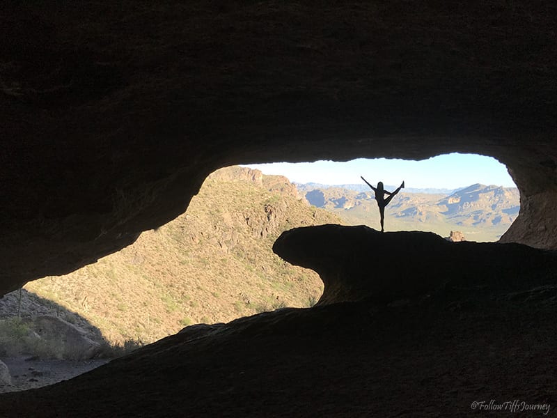
We left LA early in the morning around 5 am and made it to Phoenix just in time for lunch. My travel buddy had been wanting to take me to a famous pizza place, Pizzeria Bianco, which was expensive but delicious and worth it to try at least once. Afterward, we headed towards Superstition Wilderness and spent the afternoon at the Wave Cave. It took us an hour to get to the Peralta Trailhead to hike to the Wave Cave. It was really hot and the trail is very exposed, starts off flat, then climbs a lot at the end, so we didn’t do much else. The trail is only 3-3.5 miles round trip out and back and took us about an hour in the heat to hike in.
We camped at Flowing Springs Campground (first come, first serve, no fees) which is just off of hwy 260, a few miles north of Payson, AZ. You basically park and set up camp anywhere and there are the basic vault toilet restrooms here. The campground is right next to the East Verde River which I’m sure is nice for the summer, but we really only came to sleep and left early morning. In my opinion, it’s not the nicest campground, but it’s a good fix for a quick night’s rest when you’re on the road and free.
DAY 2 – Saturday [November 25, 2017]
Payson, AZ → Tonto Natural Bridge → Fossil Creek Wilderness

Tonto Natural Bridge is only 9.4 miles / 15 min away which made for a quick drive in the morning. We got to the state park just after 9 am and there is a fee of $7 per adult to enter. There are 4 very short trails here and the one that leads to the bottom of the natural bridge is Gowan Trail at half mile out and back. This trail is steep and has loose dirt and slippery rocks so hiking shoes are highly recommended, especially if you are going beyond the viewing deck and exploring underneath the bridge. There’s a lot of water down there and it feels like it’s sprinkling when you’re in the middle of it, so be extra careful. It can get cold in there too, although I went in late Fall.

We left around noon and headed to Fossil Creek. There are two trails you can take in this area, and we opt for the shorter, easier, and more common path – the one mile Waterfall Trail. From the 260 fwy West-bound, you’ll turn left on Fossil Creek Rd and drive on a dirt road for 16 miles to get to the Fossil Creek Waterfall Trailhead. There is a bridge 1.5 miles before the waterfall trail parking lot which is a nice spot for a quick detour. We arrived here at 1:30 pm and the waterfall trailhead is only a few minutes down the road. The road is very curvy and I’d recommend a 4wd; Google Maps will tell you the road is closed from April-Oct, but maybe it depends on the weather because I went late November and it was open. The weather for most of my trip was hot days and cold nights. Please note that you do need a permit for this area after the first 8 miles of the dirt road, between April – October.
You can walk down underneath the bridge and dip your feet in the water, or even go for a swim if it’s warm enough. The water here is really clear and has a beautiful green-turquoise color. The road after the bridge to get to the waterfall parking lot gets a lot rougher with bigger rocks on the ground. Just go very slow. After parking, the trail is very clearly labeled. It took us about 20 minutes to get to the falls and you’re hiking along the creek the entire way.

We left a bit late and didn’t want to drive out on the dirt road in the dark so we camped at the first campground (and the only one on the same route heading back out which I believe is dispersed camping), Homestead. It’s only 2 miles from the waterfall trail parking lot.
DAY 3 – Sunday [November 26, 2017]
Fossil Creek Wilderness → Sedona (Cathedral Rock & Vultee Arch)
Cathedral Rock Hike

The morning started early and we arrived back on the 260 fwy shortly after 8 am and headed towards Sedona. The weather in Sedona was on average a high of 70s and low of mid 40s.
I started the Cathedral Rock Trail (0.7 miles one way) at 10:16 am and at a comfortable pace and plenty of breaks, I arrived at the top at 10:56 am. I’m sure you can hike it in under 40 minutes, but it’s a fun trail to explore so take your time and enjoy it! Wear shoes with a good grip – the trail climbs a lot on the red rocks and much of it has a scramble feel to it. When you get to the “end of trail” sign and take the popular photo at the end, make sure to go to the other side of the sign and scramble up the very short (& can be slippery) section to get more amazing views of the front of the trail. This part is very short and close and well worth the views.
We got back to the car around noon and headed back to the only campsite in the area that was open this time of year – Manzanita Campground, about 10 miles north. They offer reserved sites on recreation.gov as well as walk up reservations ($22/ night).
After making lunch and relaxing at the campground, we wanted to check out Slide Rock State Park which was just 0.9 miles down the street, but it requires a daily fee and the ranger said the only part of the park that’s open at this time of the year is the water slide rock part and the water is cold… so we drove back to our campsite and walked to the closest trailhead from our campsite – Sterling Pass Trail to Vultee Arch, 0.1 miles across the street.
Sterling Pass Trail to Vultee Arch
We started the Sterling Pass Trail #46 at 3 pm and finished at 6:16 pm. This trail starts with a slow incline but picks up quickly and you will soon find yourself on switchbacks all the way up to Sterling Pass. Once you make it up the pass, you hike back down the mountain on the other side to the flat trail. At 4:23 pm, we reached the sign junction for Vultee Arch. From here, you turn right and a few minutes later, you will arrive in an opening which is a great spot to get a view of Vultee Arch.
We got here at 4:37 pm and with daylight savings and the sun setting down faster, we decided to stop here and enjoy the arch from a distance while watching the sunset so we can head back before dark.


DAY 4 – Monday [November 27, 2017]
Sedona Hikes (Devil’s Bridge and Soldiers Pass)
Devils Bridge Hike

I have waited a really long time to see the Devil’s Bridge… and it was worth every second! Many of the trials in Sedona are very close to each other, this one included. There are a few routes you can take to Devil’s Bridge (Trail 120). We opt for route 1 which is the easiest and shortest.
If you have a 4×4 / high clearance vehicle, you’ll be able to drive all the way up to the trailhead for a 0.6 mile one-way hike. There is a rather large row of rocks our Subaru couldn’t make it up (about a foot high) so we turned left into the parking lot and hiked the 3.6 miles round trip instead. You end up walking on the dirt road for about a mile before reaching the actual trailhead, but this part is all flat.
The Devil’s Bridge Trail has 400 ft elevation gain which is gradual at the beginning and ascends a lot more about halfway through.
We started from the parking lot at 8:48 am, got to the Devil’s Bridge Trailhead at 9:16 am, and to the top of the bridge at 9:40 am. Coming down took us 14 minutes, but I spend a lot of time taking photos going up a trail that I don’t stop much for photo ops heading down.


Soldier Pass Trail and Seven Sacred Pools
Next on our list was Soldier Pass, Trail 66, less than 30 minutes away from Devils Bridge. The parking lot for this trailhead is buried in a residential neighborhood and has space for maybe 15-ish cars. If I recall correctly, there are “no parking” signs for the residential areas so be sure to go early and get a spot in the lot! We got lucky that someone was leaving and there was an empty spot and started our hike at 11:50 am.

Soldier Pass Trail is 2-mile one way but I sought this trail out for something else. The trail is not clearly marked after the Devil’s Kitchen/ sinkhole, but enough that you can find your way for a Sedona hike.
I completely missed the Seven Sacred Pool on my way in because it was so dry, but be on the look out for it when you come to the sign for the Soldiers Pass / Brins Mesa and Jeep Road junction.
To get to the Soldier’s Arch/ cave, there is an unmarked trail that you’ll see after the pools. I passed it the first time, not making anything of it, so I don’t have any way to track it for you. But there was a row of rocks blocking it off on the right side of the trail and it looks like the photo below with rocks at the bottom (the pic after the seven sacred pools).
I dropped a pin on Google Maps so here are the rough GPS coordinates (34.897686, -111.787846). If you go and use my coordinates, please let me know if it takes you to the right spot!
From here, the trail will be the detour on the right. It’s narrow at first but widens up completely and you just continue in one straight direction. If you head up to the “cave”, be careful as the rocks are loose. Remember, nothing is worth getting hurt outdoors.
Both of these trails are short and rated as moderate-difficult, but you’ll have a good half day left to explore more. I spent my afternoon catching up on work and exploring the strip of the city. There’s a self-guided walking tour on the side of the road (I think it was the 89) which was pretty really neat. It tells you about the history of Sedona.


We stayed at Manzanita Campground again this evening.
DAY 5 – Tuesday [November 28, 2017]
Sedona West Fork Oak Creek → Flagstaff → Navajo Nation

Down the street from the campground the next morning, roughly 10 minutes or so, is Call of the Canyon (Red Rock Secret Canyon Wilderness) where you can find the popular West Fork of Oak Creek Trail.
You have to pay $10 per car to park in the lot and there is no other area or street to park at, but it’s worth it. The trail is 2 miles one way and that does not include the walk to the trail (roughly 20 minutes, maybe 1 mile).
Once you start on the actual marked trail after the abandoned house to your right, the trail will head straight for the creek which you will need to cross… 13 times. The trail is gradual and fairly flat along the stream the whole time and the crossings are obvious enough that you’ll know if you missed it.
I started at 9:20 am and the trail was very shaded since there’s a lot of trees and you’re next to the canyon walls the whole time. Must have been around 60 degrees or so, but as with any hike, you warm up quickly. The end of the 2-mile hike is very narrow and the walls are lower and concave.
The trail goes on for another 11 miles, I believe, but you have to walk in the water to keep going and I don’t know if it’s a well-maintained trail or not.
We spent our entire morning exploring this area and headed north towards the last stop of our road trip at 1:30 pm.


DAY 6 – Wednesday [November 29, 2017]
Last Day: Navajo Nation→ Heading Home to SoCal
One last adventure before our long journey back home.
Booking travel soon?
Please consider using my affiliate links below. It costs nothing additional for you but helps me maintain the ever-increasing costs of running a travel blog:
General travel through Tripadvisor here.
Book your flights here.
Book your accommodations here on Expedia, Booking.com, Hotels.com, and VRBO.
Book your car rentals here.
Book your tours here.
Book your travel insurance here.
Shop my favorite gear here.
Thanks for reading and don’t forget to practice Leave No Trace
feel free to ask any questions you may have below =)
Tiff, the owner and author of Follow Tiff’s Journey, is a California/ Colorado-based adventurer and outdoor connoisseur who divides her heart between the Eastern Sierra Mountains and the Colorado Rocky Mountains. Despite her fear of heights, she’s become a seasoned mountaineer, ultralight hiking and backcountry camping enthusiast, expert road trip planner, and a fervent explorer of alpine lakes, natural hot springs, and sandstone canyons.
With 10 years of experience exploring the outdoors, her blog is your go-to source for all things wilderness, offering invaluable insights and pro tips, essential gear recommendations, and awe-inspiring stories from her adventures.
Join Tiff on her quest to share the wonders of nature and inspire others to follow their own path in the great outdoors.
Loved it! Thanks for sharing and especially so detailed, it’ll definitely help when I check out some of these places. Beautiful photos, too!!
Thanks so much, Chrissie! Hope you have a great time when you make it out there 🙂
Welcome to the desert! You have hiked some of my favorite trails. You blog and Instagram are amazing, thanks for sharing 🙂
-Amanda
theoccasionalhiker.com
Hi Amanda! Thank you for the sweet comment! Sedona surely has some of the best desert trails to explore… anywhere in Arizona and Utah does actually!
Nice roadtrip! You selected some places and your itinerary was very efficient. I’m hoping to knock out LCR in the next few months.
Thanks, Aaron! Have a great time at LCR!
Loved the Litte Colorado section. Beautiful scenery. I imagined how amazing that trip would be.
Thanks, Shannon, it was absolutely incredible! I was in awe the whole time and definitely recommend adventuring over when you get a chance =)
thank you for sharing. I promise to leave no trace and respect your trust in us!
Loved the article. Great write up! Do you have climbing experience that made you feel more comfortable with some of the bouldering on the Salt Trail or do you think someone who is a moderate biker could manage? Thanks so much 🙂
Thank you, Emily! I’ve scrambled a lot but nothing quite like this. I think if you’re up for an adventure, not scared of heights, and careful, you’ll manage!