
Icehouse Canyon in Angeles National Forest is home to many peaks in the Southern California region including the locally famous Cucamonga Peak and Mount Baldy, but if you are looking for a less-trafficked trail in the same area, Bighorn Peak is a great option for a moderate hike with similar views.

HIKE TO: Bighorn Peak
TRAIL: Icehouse Canyon > Ontario Peak Trail
MILES: 10.57 miles (out & back)
TIME: 4:39 hrs (4 hr moving time)
DATE I WENT: 10/25/20
DIFFICULTY: moderate
ELEVATION: 8441 ft
ELEVATION GAIN/ LOSS: 3428 ft
HIKE PERMIT: no
PARKING PERMIT: yes, the US National Parks Pass doubles as an Adventure pass in Angeles National Forest
LOCATION: Angeles National Forest/ San Bernardino National Forest, Cucamonga Wilderness
Gear List for Big Horn Peak (8,441 ft) Day Hike
- Midlayer fleece – it’s always cooler at high altitude
- Trail leggings with zippered pockets
- Hiking shoes
- Small day pack
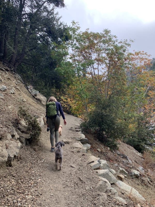
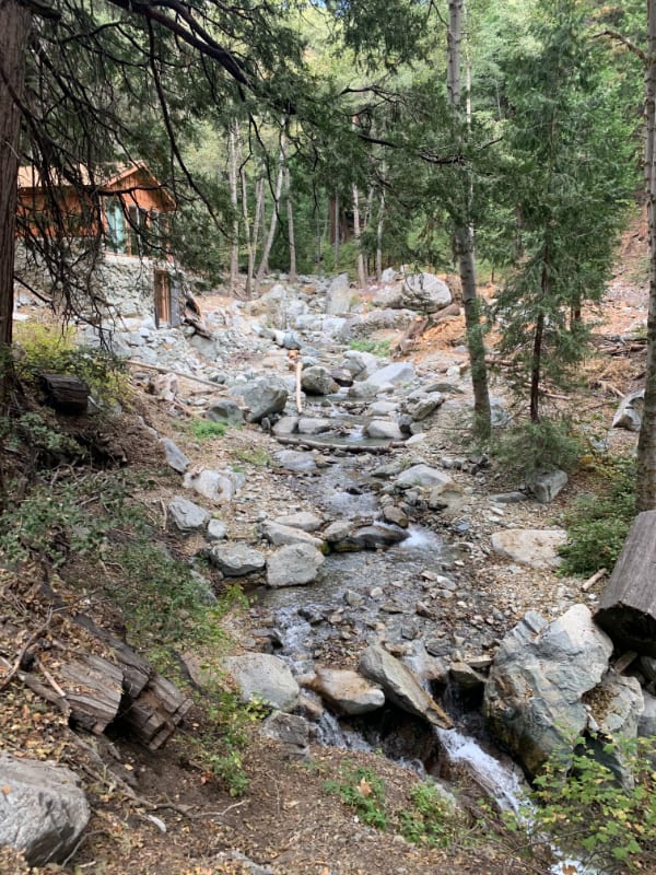
Ice House Canyon Trail


[10.25.20] We started on a late Sunday morning at 11 am and initially set out for Cucamonga Peak to catch an inversion, but our plans were constantly changing. The parking lot was packed (we parked a good 10 min walk down the road) as were the trails so when we ran into Kinga’s friend in the mountains, we decided to join him to Bighorn Peak since neither of us had been before.
Fun fact: Did you know Icehouse Canyon is on the border of Angeles National Forest and San Bernardino National Forest? Icehouse Canyon Saddle, Bighorn Peak, and Ontario Peak all lay along the border of ANF / SBNF but Cucamonga Peak is actually in San Bernardino National Forest.
The beginning part of the hike just to Icehouse Canyon Saddle is a popular trail: the beautiful 3.6 miles with 2552 ft elevation gain alone makes it a good workout, but the numerous peak options at the junction offer a variety of hike options.
The first mile is fairly flat with a small but gradual incline and hikes along the creek. The second mile is still flat-ish but has a lot of rocks on the trail. The last 1.6 miles to Icehouse Canyon Saddle are switchbacks on a narrow dirt trail with an elevation gain you’ll feel.


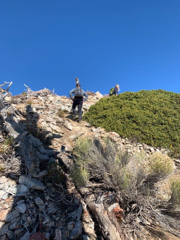
Bighorn Peak Trail
From Icehouse Canyon Saddle, you can hike north to Timber Mountain and the Three T’s, southeast to Cucamonga Peak, or southwest to Ontario Peak and Bighorn Peak.
Bighorn Peak is about 2 miles further from Icehouse Canyon Saddle with only 876 ft of elevation gain. The trail continues on Ontario Peak Trail for 1.2 miles and also passes Kelly Camp (a backpackers camp 1 mile from saddle). Then you reach the ridge where you continue left for another 0.8 miles to Bighorn Peak (heading right at the ridge leads to Ontario Peak – 2.8 miles from the saddle). If you’ve never hiked to Ontario Peak, I’d recommend making the detour although I think Bighorn Peak is better IMHO.


The ridge is unmarked but well-trafficked to the peak so you can’t get lost as long as you have a general sense of direction.
The views north of the ridge (to your left hiking up) consist of Mt. Baldy (you can see Baldy Bowl) and Angeles National Forest. The views south of the ridge (to your right) are San Bernardino National Forest.


Bighorn Peak is an epic summit because you get an unobstructed 360-degree view from the top. We had the summit and trail (from the saddle to the summit) almost entirely to ourselves which was really nice considering the overwhelming amount of cars parked.


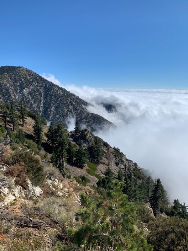
We planned to hike up here to get above the clouds. It had been cloudy for several days in the city and when it’s overcast for a while and the clouds look super low, the odds of hiking above the clouds seem high. I don’t know if there’s any truth to it, but theoretically, it makes sense, right?
The clouds kept rolling through which made the scenery hiking down ever-changing and we also got to see some Fall colors in Icehouse Canyon below!


Please note that the Winter weather can be harsh – Mt. Baldy area gets a lot of snow and may not be suitable trail conditions for inexperienced hikers. Always be prepared for all weather conditions – Even the roads get dangerous to drive. Remember that these mountains range from 5k-10k feet in elevation and have very different trail conditions than in the Spring, Summer and Fall… so here’s a reminder to please do your research before you go and be prepared.
Booking travel soon?
Please consider using my affiliate links below. It costs nothing additional for you but helps me maintain the ever-increasing costs of running a travel blog:
General travel through Tripadvisor here.
Book your flights here.
Book your accommodations here on Expedia, Booking.com, Hotels.com, and VRBO.
Book your car rentals here.
Book your tours here.
Book your travel insurance here.
Shop my favorite gear here.
Blog Recommendations for Winter Hiking: Safety, Pack List, and Resources
Thanks for reading! I’d love to hear your thoughts below 🙂
Let me know in the comments section if you have any questions, comments, or suggestions & don’t forget to practice leave no trace
Tiff, the owner and author of Follow Tiff’s Journey, is a California/ Colorado-based adventurer and outdoor connoisseur who divides her heart between the Eastern Sierra Mountains and the Colorado Rocky Mountains. Despite her fear of heights, she’s become a seasoned mountaineer, ultralight hiking and backcountry camping enthusiast, expert road trip planner, and a fervent explorer of alpine lakes, natural hot springs, and sandstone canyons.
With 10 years of experience exploring the outdoors, her blog is your go-to source for all things wilderness, offering invaluable insights and pro tips, essential gear recommendations, and awe-inspiring stories from her adventures.
Join Tiff on her quest to share the wonders of nature and inspire others to follow their own path in the great outdoors.