
HIKE TO: Mount Baldwin
TRAIL: Convict Creek Trail
TRAILHEAD: Convict Lake Trailhead
MILES: 15.85 miles
TIME: 2 days / 1 night (9 hrs moving time)
DATE I WENT: 7/17/22 - 7/18/22
DIFFICULTY: easy-moderate; requires class 2 scrambling
ELEVATION GAIN: 4986 ft
HIKE PERMIT: yes for overnight camping, not for day hikes
PARKING PERMIT: no
LOCATION: Eastern Sierra, Inyo National Forest
Day 1: Hike Convict Creek to Camp at Mildred Lake
We picked up walk-up permits for Mount Baldwin via Convict Creek at the Mammoth Lakes Visitor Center Sunday morning before our hike. You can check online for cancellations and all “no show” permits are released at 11 am.
The hike from Convict Lake is longer than other access points to the summit of Mount Baldwin (12,624 ft) but it is the easiest/ non-technical route up. It can be done as a day hike, which I believe may be more common, but I really wanted to camp in the canyon and love sleeping in the wilderness so we backpacked to Mildred Lake and day-hiked to the summit.
The Convict Lake trailhead parking lot, different than the Convict Lake Loop trailhead where the marina is, does not have any bear lockers for food storage so plan ahead. The turn-off for this parking lot is just before the Convict Lake Restaurant.
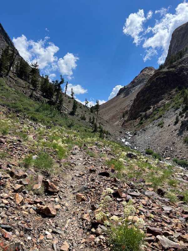
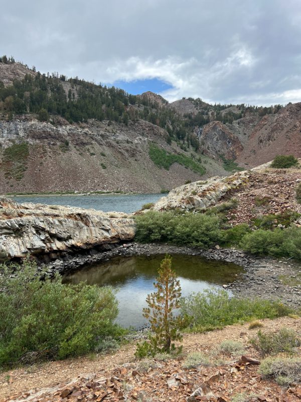
We started our journey to Mount Baldwin via Convict Creek at 11:50 am and the trail to Mildred Lake was longer than I expected, but it was an easy hike. It was a gradual incline the entire way with little-to-no shade coverage for most of it. The mosquitos right now are surprisingly not bad, unlike many other trails in the High Sierra. The trail follows along Convict Lake for about a mile to the junction of Mildred Lake and Lake Dorothy. Head right towards Mildred Lake and follow Convict Creek into the Canyon.


There is a creek crossing at the old washed-out bridge 3.75 miles from the trailhead. Most people we met during the two days said it was not a problem and you can cross the logs by this old washed-out bridge but I’m here to tell you – you can’t, unless you are very brave and fast with skipping rocks and not afraid to fall.
Creek Crossing Levels: Earlier in the season, like now in July, Convict Creek is flowing strong with white water rushing through it. We failed to find an easy access point to cross to the other side and walked up and down Convict Creek for a while looking for an easy and dry crossing. The spots that looked mostly crossable all had a small, but big, leap over white water which we didn’t want to chance slipping. We spent about 45 mins looking, figuring out how to get across, but with a high chance of thunderstorms coming that afternoon, we decided we had to just go. Ultimately, we found the one section that was more shallow and had no white water to cross but one of us still fell on the slippery rocks in the creek so be careful! I’d recommend wearing light, non-waterproof hiking shoes to power through. It’ll dry quickly and not waste time here. Or hike Mount Baldwin a little later in the summer.


The creek crossing is not an issue later in the season once the water levels drop though. Hiking back was an issue as well. We, again, looked at the old washed-out bridge everyone talked about and it didn’t seem safe to cross. The idea of slipping and being swept down by the current was not something we wanted to chance. We ended up hiking downstream further and found some boulders that were not as intimidating to cross and managed to stay dry this time… only to have the rain get us wet for the hike out.


Moving forward…
The hike to Mount Baldwin continues along the side of the canyon and has a few uphill switchbacks before continuing gradually again. The trail is a lot of rocks and sometimes gets as narrow as one-foot wide. About 45 mins later, we reached Mildred Lake at an elevation of 9,775 ft and 5.16 miles from the trailhead.
The dark clouds were looming just ahead of us above Red Slate Mountain but we wanted to get a little closer to the bottom of the “off-route” section of the climb for a slightly shorter summit day, so we continued on halfway through the meadow about 0.4 miles and found a huge sandy section to set up camp around 3:40 pm. The trail through the meadow is very marshy and although you lose it at some points, you’re literally just going straight through it and staying along the left side of the creek for most of it. From camp, you cannot see Mount Baldwin – not until you round the corner and see where you head up and out of the meadow.


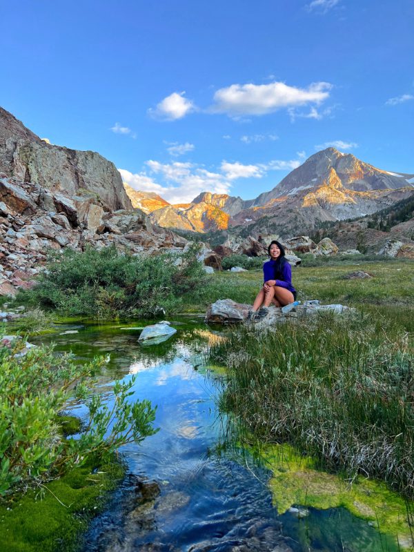
The storm never came and it was HOT hanging out all afternoon, baking in the sun until it finally dropped behind the mountains around 6 pm. We were the only campers out there 🙂
Day 2: Summit Mount Baldwin and Hike Back Out
We started our climb at 6:09 am from camp and had about 2,800 ft of elevation gain to summit Mount Baldwin. The trail continues through the meadow until the first incline you see on the left (about 10 mins for us). There were two obvious ways up – we went up along where the water runs down but crossed it where it’s still flat-ish, then went up a few feet to connect with the other route. This little creek is the last water source before heading up Mount Baldwin.


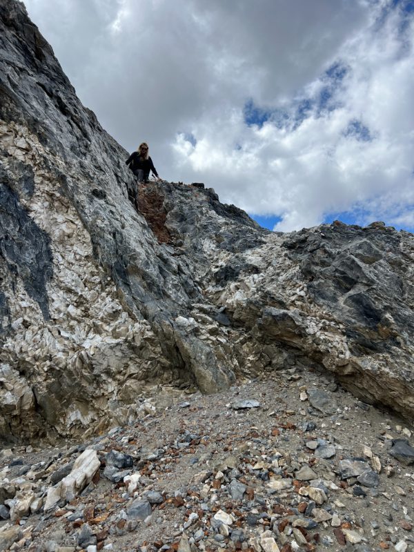
There is a use-trail that takes you up to the summit of Mount Baldwin, but you will still want to know how to route-find to stay on it as it becomes unclear in several sections if you’re not paying attention. It’s a LOT OF SAND which makes for unpleasant uphill hiking, but easy downhill, and also cairns to guide the path. The trail is class 1-2.
At mile 6.8 from the TH, you end up in a gully-like, enclosed space. Go left up it, otherwise, you will end up going right on the opposite side and traverse across when you see the trail from above it.
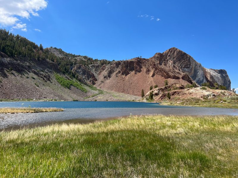
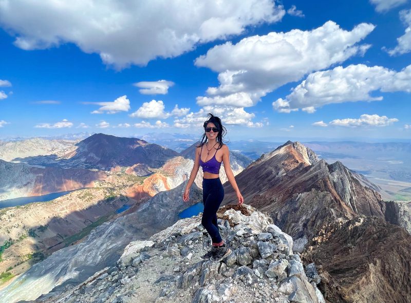
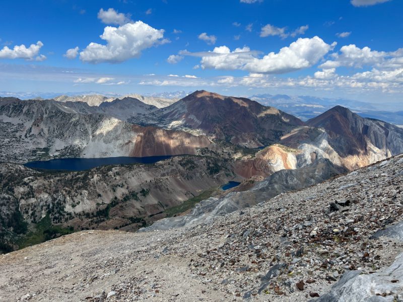
Just under 7 miles, you get your first views of Bright Dot Lake before reaching the ridge that leads you to the old mine and summit. This lake was actually the reason I wanted to climb Mount Baldwin. I saw a photo of Bright Dot Lake a few years ago, surrounded by colorful red mountains, and decided I had to see this gem for myself.


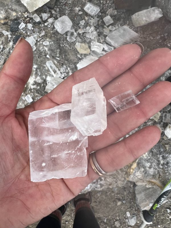
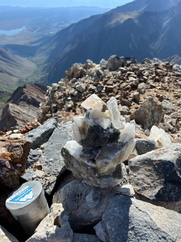
The abandoned Bausch and Lomb Mine on Mount Baldwin left a ton of clear calcite crystals which you can find just before the final sandy, scree summit push.

This final section to Mt.Baldwin peak is a choose-your-own-adventure slog. There are two use-trails to reach the top of Mount Baldwin: the farther one is easier to spot on the way up, and the closer one is obvious on the way down, just make sure you record your tracks so you know where to drop down and reconnect with the trail. However, you can just beeline for the summit. I didn’t stay on either trail fully and just went for it. There is no easy way to the summit; it’s going to suck regardless, but it’s easy hiking.
It took less than 3 hrs to reach the summit of Mount Baldwin (12,624 ft) this morning: 2.44 miles from camp and 2886 ft of elevation gain. The 360 views of Convict Creek Canyon, McGee Canyon, Bright Dot Lake, Lake Dorothy, Lake Genevieve, Mildred Lake, and all the peaks were incredible. I enjoyed it for about an hour before heading back down to break down camp and hike back out. Oh ya – there’s cell service at the summit!


It rained almost our entire hike out of Convict Creek… if you’re unfamiliar with the Eastern Sierra mountains, afternoon thunderstorms are very common in the summer. We had the perfect summit morning weather, but it was cloudy, breezy, and raining for most of our trip. The wildflowers are all out right now though!


If you have not hiked Mount Baldwin, it’s definitely worth exploring. It is not a technical peak so hikers (not climbers) are capable of reaching the summit, and it offers the next level of excitement if you’re looking for a hike off the beaten path... while still on a path.
Gear List: One-night camping in the Sierra backcountry with one class two peak climb
My pack weight was 14 lb with one night worth of food – learn tips on how you can pack lighter to move faster on my Ultralight Backpacking Guide
- Big Agnes 2-Person Ultralight Backpacking Tent
- 30 degrees Ultralight Backpacking Quilt
- 50L Ultralight Backpack – way more space than I needed for one night
- Inflatable Ultralight Pillow – only weighs 1.6 oz
- Synthetic Insulating Jacket
- Ultralight Rain Shell – weighs only 5oz, great to pack on all trips!
- Portable Backpacking Stove
- Water Filter
- Long Sleeve Sun Shirt Hoody – highly recommend this!
Booking travel soon?
Please consider using my affiliate links below. It costs nothing additional for you but helps me maintain the ever-increasing costs of running a travel blog:
General travel through Tripadvisor here.
Book your flights here.
Book your accommodations here on Expedia, Booking.com, Hotels.com, and VRBO.
Book your car rentals here.
Book your tours here.
Book your travel insurance here.
Shop my favorite gear here.
Thanks for reading!
Have you explored Convict Creek?
I’d love to hear your thoughts in the comment section below 🙂
& please don’t forget to practice leave no trace!
Tiff, the owner and author of Follow Tiff’s Journey, is a California/ Colorado-based adventurer and outdoor connoisseur who divides her heart between the Eastern Sierra Mountains and the Colorado Rocky Mountains. Despite her fear of heights, she’s become a seasoned mountaineer, ultralight hiking and backcountry camping enthusiast, expert road trip planner, and a fervent explorer of alpine lakes, natural hot springs, and sandstone canyons.
With 10 years of experience exploring the outdoors, her blog is your go-to source for all things wilderness, offering invaluable insights and pro tips, essential gear recommendations, and awe-inspiring stories from her adventures.
Join Tiff on her quest to share the wonders of nature and inspire others to follow their own path in the great outdoors.