

HIKE TO: Big Pine Lakes (First Lake, Second Lake, and Third Lake)
TRAIL: Big Pine Creek North Fork
MILES: 14.54 miles out and back (5.5 miles to the popular Second Lake)
TIME: 3:41 hrs up, 3:29 down(2 hrs up at a faster pace)
DATE I FIRST WENT: 6/7/16 - 6/8/16
DIFFICULTY: moderate
ELEVATION GAIN/ LOSS: 2,471 ft
HIKE PERMIT: yes for overnight camping, no for day hike
PARKING PERMIT: no
CAMPFIRES: NOT ALLOWED - please practice leave no trace
LOCATION: Eastern Sierra, Inyo National Forest
Big Pine Lakes is one of the best hikes in California. If you are planning a hiking trip to the Eastern Sierra Mountains, you have to visit Big Pine Lakes in John Muir Wilderness. Born and raised in California, I never knew about Big Pine Lakes until 2016 and have hiked and camped here multiple times per year, every year since — it’s stunning! It’s only 4.5 hours from Los Angeles and the moderate hike ends at glacial-fed turquoise lakes in the Palisades. I call this the Patagonia of California.
Everything you need to plan your Big Pine Lakes hike—in one place.
Get my 38-page Ultimate Guide with mileage, map, gear, permits & pro tips → [Grab it here]

Do you need a permit for Big Pine Lakes?
You can day hike to Big Pine Lakes without a permit, but we chose to overnight camp just because I missed backpacking and an Inyo National Forest Wilderness Permit is required to camp overnight. Normally, you’ll want to confirm your permit before 10 am the day of otherwise they will release your permit; we were not aware of this so right after I got my “no show” email, I had to call them to let them know we were on the way to pick up our permit. We picked up our permit at the Eastern Sierra InterAgency Visitor Center (the closest permit issuing station if you are coming from the Los Angeles area).
If you’re lucky enough to get a backpacking permit to camp by the lakes, consider bagging a 13k ft peak and hike all 7 Big Pine Lakes and climb Cloudripper for a bigger adventure!

What is the best time of year to hike Big Pine Lakes?
I’ve hiked Big Pine Lakes Trail every month from May – November since 2016 and have found the best times to hike Big Pine Creek North Fork:
- May on a dry year is a good time to hike to Big Pine Lakes. It’s beautiful with some snow on the trail and mountains still. However, on a good/ heavy snow year, I’d hold off.
- June is a great time to visit Big Pine Lakes. On a good snow year, there will likely still be snow after Second or Third Lake, but the lakes should be a beautiful deep turquoise color. On a dry year, I would not expect snow unless you’re climbing further up and the lakes will be a beautiful vibrant turquoise, especially mid-late June. However; June also tends to be the worst time for mosquitoes in a dry year.
- July and August are the best time to hike Big Pine Lakes for fair-weather hikers so wilderness camping permits will also be hardest to obtain for these months. These months are when the lakes are most vibrant and milky blue/ turquoise colored. The days are warmest so you can swim in the lake, and the daylight is longest. However; it gets hot quickly so start your hike early. July and August are also when afternoon thunderstorms are common in the Eastern Sierra Mountains. And lastly, August tends to be when fire season starts so the air quality can get smoky, but I will also mention I’ve been in August during fire season when the AQI is really bad and was perfectly fine camping at Second Lake.
- September is one of my favorite times to hike Big Pine Lakes. The water is still bright turquoise when the sun hits it, but not as much as in Summer of course. The crowds start to die down in September, especially on weekdays. The days are warm but the nights cool down fast which is fine with the proper layers. Fall colors can start appearing in mid-late October.
- October is an amazing time to visit for Fall Colors. The Big Pine North Fork trail gets fall foliage from the Aspen trees and the lakes hold a deeper turquoise teal color. The weather is definitely a lot cooler though! I bivy-camped at 14k ft in early October in my Katabatic’s 30° sleeping bag and as very comfortable.
- November is surprisingly nice to hike Big Pine Lakes still. Yes, it’s much later in the season for a high-altitude hike and the temperatures can certainly and likely drop below freezing temps, but with the right gear, permits are easier to get and you can camp with little-to-no one around and enjoy the deep teal colored lake still. It’s worth it. I’d recommend a light backpacking quilt (my favorite is Katabatic’s 30° quilt) or if you run very cold and the forecast is showing below 20 degrees, go with a 0° sleeping bag. However, be prepared cause Winter is just around the corner and snowfall is always a possibility.
Booking travel soon?
Please consider using my affiliate links below. It costs nothing additional for you but helps me maintain the ever-increasing costs of running a travel blog:
General travel through Tripadvisor here.
Book your flights here.
Book your accommodations here on Expedia, Booking.com, Hotels.com, and VRBO.
Book your car rentals here.
Book your tours here.
Book your travel insurance here.
Shop my favorite gear here.
What to pack for Big Pine Lakes
Day Hike Gear List
- Hiking boots — Danner Mountain 600
- Hiking socks — Darn Tough and FLite XT are my favorite for summer hiking
- Read Best Hiking Socks Gear Guide here.
- Day pack — Pingora has been my go-to for a durable, full day hiking pack. The shoulder strap pockets are very convenient for your phone, snacks, and sunblock.
- Down jacket and light rain jacket because the Eastern Sierra is known for afternoon thunderstorms in the summer
Backpacking Gear List
- Beginner-friendly overnight backpack recommendation: Osprey Aura 50 L or Pingora Outro 55 L
- Lightweight tent — Big Agnes Tiger Wall
- Sleeping bag or quilt — I’d recommend a 30 degrees quilt for Summer/ Fall for optimal weight-warmth ratio
- Sleeping pad — invest in a good one, this may be the most important part of backpacking. If you don’t sleep well or warm, it affects the rest of your trip and a warm sleeping bag alone is not good enough.
- Thermarest makes the best warm sleeping pad if you run cold
- Big Agnes makes a good 3-season pad that comes with a very light and helpful self-pump
- Food storage bag — bear bag or bear canister
- Water filter — BeFree 1 L is very lightweight and convenient for backpacking
- Portable stove — Jetboil Minimo is fast and convenient! I’ve been using this one for 9 years
- My personal favorite freeze-dried meals I’ve tried after 10 years of backpacking
- Trowel & wag bag 💩
- See full beginner’s backpacking guide here.
How many lakes are Big Pine Lakes and which ones should I visit?
We hiked the Big Pine Creek North Fork Trail. This trail has 7 lakes (8 if you include Black Lake) but our goal was only to hike to and camp at Third Lake. Second Lake, Third Lake, and Fifth Lake are the only lakes that hold impressive turquoise colors from the glacial melt. First Lake is turquoise too but not as vibrant as the season goes on.
What is the best lake to camp at Big Pine Lakes?
Second Lake, Third Lake, and Fifth Lake are the best from my experience. The lakes are the most turquoise blue color, but First Lake is also vibrant. There are many campsites tucked away in the trees by each lake so please respect other camper’s space and don’t pitch your tent twenty feet away from a stranger.
How do you get to Big Pine Lakes CA?
The famous turquoise Big Pine Lakes in California is located 11 miles from Big Pine, CA in the Eastern Sierra Mountains. From Los Angeles, it is about a 4.5 hr drive without traffic: 4 hours to the town of Big Pine Lakes and another half hour up the mountain road. The road to the trailhead is paved the entire way.
Pro Tip: stop by Copper Top BBQ after your hike for the best BBQ along Hwy 395! For more recommendations on Hwy 395 must-stops, click here.

Big Pine Lakes Trailhead and Parking Lot
THE JOURNEY BEGINS: We got to the parking lot and started hiking around 1 pm. The Big Pine Lakes Trailhead is a 10-mile drive on a paved road into the mountains from the town below, Big Pine. Google Maps will take you straight here. There is a separate parking lot for day hikers and overnight hikers (the overnight parking lot is half a mile before the day-use trailhead).
Parking can get very crowded but you can pull off to the shoulder of the road.
Be Bear Aware
There are definitely bears in the area, including the parking lot, so be bear aware!
There are bear lockers and restrooms at both trailheads; leave anything scented or food you do not want to bring from your car in the bear lockers – label your items with your name and exit date.
You need a BEAR CANISTER or bear bag if you plan to stay overnight.
Also, bring BUG SPRAY if you’re going in late Spring/ early Summer! There were so many mosquitoes throughout the trail and I got lit up on this trip. Bugs tend to come out in June/ early July depending on the snowmelt of the season.
Big Pine Creek Campground
If backpacking is not for you, there is a campground and a small Glacier Lodge (check for availability here) at the trailhead you can stay at. Then you can day still hike Big Pine Lakes – start early.

Big Pine North Fork – Trail Report
Trip report from my first visit in 2016. For more recent trip photos, see my blog post for Big Pine Lakes to Cloudripper in 2021 here.
It’s been a while since I’ve been backpacking and I must admit – I missed my big Osprey backpacking pack. I haven’t been since I summit Mt Whitney last August, so last week, I decided I was going back to the Eastern Sierras to backpack just for one night [6.7.16 – 6.8.16]… and talked my adventure buddy into going with me.
There is a trail that starts from the overnight hiker’s parking lot which is supposed to be the Big Pine Creek trailhead, but we weren’t entirely sure so we walked along the road to the end and began where the day users start. We started here at 1:21 pm.
This trail is so beautiful because you are walking along North Fork Big Pine Creek for most of the trail — you always hear the water from the creek in the surrounding area and there are plenty of options to filter water! So we start off walking along Big Pine Creek. Keep an eye out for the “trail” signs in the beginning – I think we saw two, but you can’t get lost.
10 minutes in, we came across the first waterfall (keep in mind, I’m a decent-paced hiker but did this with a big overnight backpacking pack, so day hikers may get there faster).
If you’re from LA, you know that we don’t have “real” waterfalls… now, THIS was a real waterfall! It flows strong! Just a minute later (0.37 miles from day user parking lot), you will soon come across the fork and sign for South Fork Big Pine / North Fork Big Pine: go right to take the North Fork Trail leading to the beautiful blue-green lakes.


At 1:47 pm, we came to an opening with no signs specifying right, left, or straight. I went with a hunch and steered right — follow me! Straight in front was another bridge and just on the other side was the NF Big Pine trail sign. This is where the backpackers’ trail for the South Fork to Finger Lake connects with the day users, but keep left to stay on the trail.
For the next mile, you are not walking next to the creek. The trail has very limited shade and this was definitely the hottest part of the hike. You can see the second waterfall at a distance, but it’s farther than you think. The trail starts to ascend a lot more here with a large switchback as well, probably the most during the entire hike to the start of the lakes.
At 2:15 pm, the trail steers a hard right and climbs even higher – the elevation gain was not too bad, but with the heat of the summer sun and the weight of my pack… the incline slowed me down to say the least.
There were many pink/ lavender and yellow wildflowers that bloomed and lit up the trail – it was actually one of my favorite parts of the hike. Keep a lookout for another trail that goes left (u-turns) along this part of the trail. It’s soon after you pass this unique tree, but you will want to make sure you take that route instead of continuing straight to who knows where.
At the top of this switchback, you connect with the overnight parking lot trail.
2:20 pm, 1.82 miles, you will see another NF Big Pine trail sign to ensure you took the right path.
Just over 2 miles from the start, you will approach the second waterfall which we came to at 2:35 pm, and just around the corner from that is the John Muir Wilderness / Inyo National Forest trail sign.
NOTE: at this time of year, there were a LOT of ladybugs!! I mean I walked for about four mins (back along the creek) with swarms of ladybugs flying all over me, all up in my face, and attaching onto any part of me they could. and yes, I time out and track every detail of my hike just so I can share it with you. Anyways, I’m pretty sure the ladybugs are harmless and once you pass them, they don’t go chasing you. It was just surprising and a bit annoying.


The trail becomes “flat” again and at about 2.64 miles (2:50 pm), there is a big rock that offered some much-needed shade for a break, while my friend backtracked his steps to locate something he dropped.
We stayed about 10-15 minutes before carrying on and it felt really nice to take my backpack off! You soon enter back to the shades of the beautiful, tall green trees, and at 3:13 pm, you pass the Big Pine Creek Wilderness Ranger Camp. This is just over the 3 miles mark.
With just a little incline here and there, you will continue to trek along the creek and mostly in shade in the middle of the afternoon.


At the 4 mile mark (2 hrs), you will get your first glimpse of Temple Crag in the distance! At 4.45 miles, 17 mins later, you will cross a small stream and a larger rock-skipping water area within ten mins. If this part confused you, just know you’ll encounter water with your steps within ten mins of your first glance of Temple Crag.


At 4.89 miles (2:38 hr), we finally saw the sign for Lakes 1-7 / Black Lake. Continue straight to the pretty green water! 8 mins later, and 5.16 miles from the parking lot… hello First Lake! We arrived at 4:19 pm and at this time of day, the water was gleaming green (it was a lot prettier when we passed through the next morning). We stopped for a quick photo before wanting to move on our way to the other lakes because we heard they were prettier.


5.35 miles and less than 10 minutes from First Lake – hello Second Lake! It took me a while to get here my first time but I’ve gotten up as quickly as two hours on other trips. This one took my breath away. The water was green and beautiful and the view of Temple Crag straight on was so dramatic and just makes you go woah… 😀 We saw some other backpackers set up camp around here, but I’ve always wanted to hike to Third Lake so fifteen minutes later, we trekked on to find our last stop.

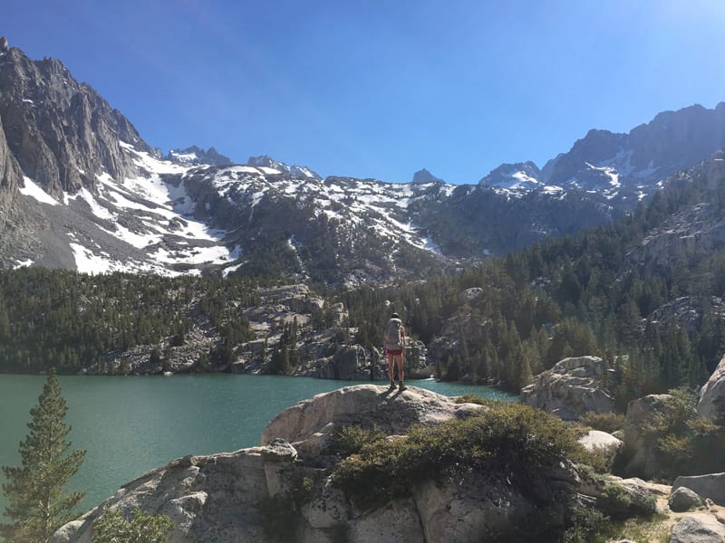
Third Lake is a bit farther apart than First and Second Lake. We arrived here at 5 pm/ 6.22 miles/ 3.5 hrs from the start. At this time of day, there was plenty of daylight that just brought out the colors of the lake.
There is a small waterfall on the opposite side of the lake which feeds the lake water from the melting Palisade Glacier; that water source is also the reason of the unique turquoise/ green water. You get a different angle of Temple Crag from here but it’s still awe-mazing!


We set up camp, ate dinner, and waited for the sun to go down. The sun didn’t set until after 8 pm and at 9 pm… there was still light outside! I only remember this because my friend was waiting for darkness in the sky so he could get some shots of the stars.
This is my first backpacking trip in the Eastern Sierra aside from Mt. Whitney so I was still pretty excited about the long daylight. Since we weren’t moving around much anymore, we were easy targets for the mosquitoes so I ended up hiding out in the tent most of the evening.
If Third Lake is all you want to hike to, you can stop reading here; just go back the same way you came in.
The next morning, we slept in because I wanted to wait for the sun to rise a bit higher to shine on the lake before adventuring on. At 6 am… the lake color was not very vibrant yet.
We trekked a bit further at 9:40 am and towards Sam Mack Meadow, but there was too much snow to make it much farther. There were even more mosquitos here than along the rest of the trail. We hiked until about 10:30 am before turning around, back to camp at 11:10 am (1.5 miles total), then onwards and off the mountain by 1:30 pm. Four hours later, I was back in San Gabriel Valley.


By the way, I counted 30+ bug bites when I got home!
If you have any questions, feel free to leave me a comment below. 🙂
Click here more info on the North Fork Trail description and map.
Booking travel soon?
Please consider using my affiliate links below. It costs nothing additional for you but helps me maintain the ever-increasing costs of running a travel blog:
General travel through Tripadvisor here.
Book your flights here.
Book your accommodations here on Expedia, Booking.com, Hotels.com, and VRBO.
Book your car rentals here.
Book your tours here.
Book your travel insurance here.
Shop my favorite gear here.
Everything you need to plan your Big Pine Lakes hike—in one place.
Get my 38-page Ultimate Guide with mileage, map, gear, permits & pro tips → [Grab it here]
Big Pine Lakes via North Fork Creek Throughout the Years – see below
Safe to say, I fell in love with Big Pine Lakes and have revisited it multiple times a year, every year since then.

Tiff, the owner and author of Follow Tiff’s Journey, is a California/ Colorado-based adventurer and outdoor connoisseur who divides her heart between the Eastern Sierra Mountains and the Colorado Rocky Mountains. Despite her fear of heights, she’s become a seasoned mountaineer, ultralight hiking and backcountry camping enthusiast, expert road trip planner, and a fervent explorer of alpine lakes, natural hot springs, and sandstone canyons.
With 10 years of experience exploring the outdoors, her blog is your go-to source for all things wilderness, offering invaluable insights and pro tips, essential gear recommendations, and awe-inspiring stories from her adventures.
Join Tiff on her quest to share the wonders of nature and inspire others to follow their own path in the great outdoors.
AMAZING !!!! ????
Thanks! 🙂
Great read Tiffany, were actually planning our Big Pine trip hopefully mid September! You inspire me ?
Thanks Vanessa!? Ah I’m so excited for you, you’re going to love it! Why haven’t we hiked together yet?!!
Thanks girl. Ohh I’ve just been dealing with life issues and haven’t had a car for 6 months, but back on the road! Let’s plan something ?
Yes, let’s! I feel you on the life issues… but glad you’re mobile now haha. Shoot me a direct message on IG when you’re free and we’ll make something happen! 😀
Awesome, thanks! I just got a permit for the very same hike june 7-8 this year! Would you know if it generally is this snow free that time of year? Best/B
Hi B! I think the trail conditions would really depend on the amount of rain and snowfall we get for the season, but when I went, the trail got completely snowed out starting the meadow and I’d say the Eastern Sierra is generally still heavy with snow in early June. I’d recommend you check with the permit issuing station before your trip for latest conditions. Sorry I couldn’t be of more help but let me know if you have any other questions! I’ve been back several times since this trip.
Pingback: Hike All 7 Big Pine Lakes and Climb Cloudripper 13,517 ft
Pingback: Best of 2019 Hikes | Follow Tiff's Journey
Thank you ! For sharing all your great times at Big Pine Lake . I am planning on going at beginning of fall . all your info will help and guidance.
Glad I can help, Miguel! Fall is a beautiful time to visit. The lake is still vibrant but the nights are chilly. Hope you have a great time on the trail!